Search Term Record
Metadata
Name |
San Francisco Bay |
Number of Archive records |
14 |
Number of Object records |
5 |
Number of Photo records |
42 |
Number of Library records |
13 |
Related Records
-
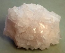
Sodium Chloride (salt)
Salt Crystal. Irregularly shaped salt crystal of 99.5% pure sodium chloride. Crystal is constructed of stacked square and rectangular prisms, ranging in size from less than a millimeter to nearly three centimeters (just over an inch). The larger prisms are concentrated along a ridge that covers about a third of the crystal's surface area, while the rest of its surface is made up of smaller formations. Along one side are several beige spots, which...
Record Type: Object
-
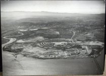
Aerial of Belmont Hills Looking East - Negative
Black and white negative shows an aerial of Belmont Hills looking east. South San Mateo and Belmont cities appear at center. Brewer Island is visible in the upper portion of the image at center. San Francisco Bay and the East Bay Hills are visible in the background. Mt. Diablo appears at upper right and Coyote Point is visible at upper left.
Record Type: Photo
-
Aerial of Brewer Island (Foster City), San Mateo, 1962 - Negative
Aerial of Brewer Island (Foster City), San Mateo, 1962. Black and white negative shows an aerial view of Brewer Island (pre development into Foster City) looking northeast. Belmont Slough is visible at right with the Los Prados neighborhood of San Mateo visible at lower left. The 1929 San Mateo-Hayward Drawbridge is visible just above and left of center, spanning the San Francisco Bay. The bridge extends into the distance toward the upper right c...
Record Type: Photo
-
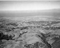
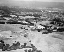
Aerial of San Mateo Hills and City of San Mateo Looking North - Negative
Black and white negative shows an aerial of the San Mateo hills before the College of San Mateo was built, looking north towards downtown San Mateo. The Peninsula Golf and Country Club golf course is visible at center right. Coyote Point appears at upper right with the San Francisco Bay in the distance.
Record Type: Photo
-
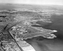
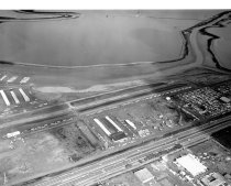
Aerial View from San Francisco International Airport (SFO), 1961 - Negative
Aerial View from San Francisco International Airport (SFO), 1961. Black and white negative shows an aerial view from the San Francisco International Airport (SFO) looking northwest. San Bruno, South San Francisco, and Oyster Point can be seen in the foreground. Past San Bruno Mountain is Brisbane, Daly City, San Francisco, the Pacific Ocean, San Francisco Bay, and the Marin Headlands. Angel Island and Alcatraz can be seen in the upper right of th...
Record Type: Photo
-
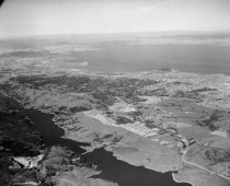
Aerial View of Crystal Springs Reservoir in San Mateo, 1961 - Negative
Aerial View of Crystal Springs Reservoir in San Mateo, 1961. Black and white negative shows an aerial view of Crystal Springs Reservoir in San Mateo. San Mateo-Half Moon Bay Road (Highway 92) crosses the reservoir. Skyline Boulevard (Highway 35) runs along right side of reservoir. Coyote Point is visible in the upper right center of the photograph, and San Francisco Bay and the East Bay are beyond that.
Record Type: Photo
-
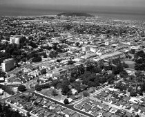
Aerial View of Downtown San Mateo, 1957 - Negative
Aerial View of Downtown San Mateo, 1957. Black and white negative of downtown San Mateo looking north from Maple Street (bottom of photograph) and Mission (far right) to Coyote Point. The San Francisco Bay is on the horizon. The Benjamin Franklin Hotel is visible in the center of the photograph on Fourth Avenue. Part of a series of 12.
Record Type: Photo
-
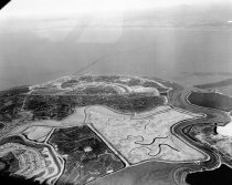
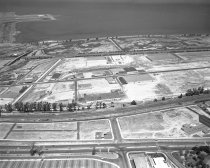
Aerial View of Foster City - Photograph
Aerial View of Foster City. Black and white photographic print on paper mounted to masonite wooden board; pine wooden cleats are mounted to back. View depicts Foster City under development. There is water in the foreground and some buildings at lower half of center peninsula and lower right of outer peninsula. The City of San Mateo can be seen in the background. In bottom right corner, vehicles are traveling over the SF Bay on Highway 92. On...
Record Type: Object
-
Aerial View of Frank's Tannery and Port of Redwood City, August 1958 - Negative
Aerial View of Frank's Tannery and Port of Redwood City, August 1958. Black and white negative shows an aerial view of the Port of Redwood City. Veteran's Boulevard is in the lower center right of the image. Bayshore Freeway (Highway 101) runs through the center of the photograph. Frank's Tannery can be seen in the center of the image. Leslie Salt Company is visible in the upper left.The Port of Redwood City is in the upper left background with t...
Record Type: Photo
-
Aerial View of Ingold-Milldale Neighborhood in Burlingame, 1957 - Negative
Aerial View of Ingold-Milldale Neighborhood in Burlingame, 1957. Black and white negative of the Ingold-Milldale neighborhood in Burlingame looking east towards the San Francisco Bay. El Camino Real is in the lower foreground of the image and Trousdale Drive is below it. California Drive and the Southern Pacific Railroad tracks can also be seen in the center. The Guittard Chocolate Factory is situated along the railroad tracks. The Bayshore Freew...
Record Type: Photo
-
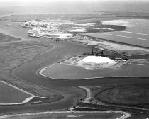
Aerial View of Port of Redwood City Looking Southeast, August 1958 - Negative
Aerial View of Port of Redwood City Looking Southeast, August 1958. Redwood Creek can be seen in the center of the image with a Leslie Salt Company platform extracting salt. More salt ponds are in the upper right of the photograph. The Port of Redwood City and Pacific-Portland Cement Plant (now known as Cemex) are visible at upper left. The San Francisco Bay appears in the background along the top of the image. Part of a series of 15.
Record Type: Photo
-
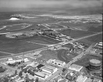
Aerial View of San Carlos Airport, 1962 - Negative
Aerial View of San Carlos Airport, 1962. Black and white negative shows an aerial view of San Carlos Airport looking east. The Bayshore Freeway (US 101) appears in the foreground, and San Francisco Bay can be seen in the background. Part of a series.
Record Type: Photo
-
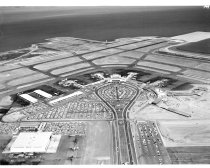
Aerial View of San Francisco International Airport, 1962 - Negative
Aerial View of San Francisco International Airport, 1962. Black and white negative shows an aerial view of San Francisco International Airport (SFO) with runways, terminals, maintenance facilities, roads and parking lots. In the background is the San Francisco Bay. Photographer Norton Pearl notes that these newly added terminals doubled the size of the airport. Part of a series 3557.
Record Type: Photo
-
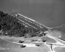
Aerial View of San Mateo Yacht Club Looking Southwest to Northeast, 1957 - Negative
Aerial View of San Mateo Yacht Club Looking Southwest to Northeast, 1957. Black and white aerial negative of the San Mateo Yacht Club looking southwest to northeast with the San Mateo Golf Course in the foreground. Two rows of roughly 100 boats are anchored in the Yacht Club harbor. The boats range from small dinghies to motorboats to sloops. The start of the stand of trees on Coyote Point is visible to the left center of the image. Part of a se...
Record Type: Photo
-
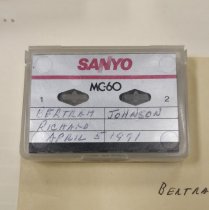
Bertram Johnson Interviewed by Dr. R. E. James - Microcassette
Bertram Johnson Interviewed by Dr. R. E. James, April 5, 1991. Audio recording of Bertram Johnson interviewed by Dr. Robert E. James on his memories of Belmont, California. Recorded April 5, 1991 on one Sanyo MC60 micro-cassette. Total time 00:57:47
Record Type: Archive
-
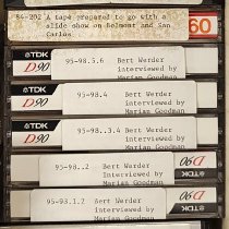
Bert Werder interviewed by Marian Goodman - Audiocassette
Bert Werder interviewed by Marian Goodman, c. 1964-1966. Subjects include his early life, Redwood City business and families, his career as Fire Warden, various industries in industries in San Mateo County, and his time in South America. Audio copied to 5 TDK D90 audiocassette tapes from original 1/4 inch reels. See 1985.043
Record Type: Archive
-
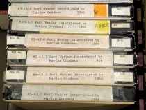
Bert Werder interviewed by Marian Goodman - Tape, Audio Reel
Bert Werder interviewed by Marian Goodman, c. 1964-1966. Subjects include his early life, Redwood City business and families, his career as Fire Warden, various industries in industries in San Mateo County, and his time in South America. Recorded on six Lafayette Radio Electronics 1/4 inch audio tapes. Each tape contains approximately 2 hours of audio.
Record Type: Archive
-
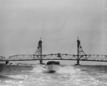
Boating on San Francisco Bay South of Coyote Point, 1959 - Negative
Boating on San Francisco Bay South of Coyote Point, 1959. Black and white negative shows motor boats on the San Francisco Bay, south of Coyote Point. The photograph was taken from a motor boat, with a woman and a small dog just visible in frame at lower left in the back of the boat. A second boat, visible at center, moves toward the camera with water splashing on either side. The 1929 San Mateo-Hayward Drawbridge appears in the background spannin...
Record Type: Photo
-
Boating on San Francisco Bay South of Coyote Point Looking Southeast, 1959 - Negative
Boating on San Francisco Bay South of Coyote Point Looking Southeast, 1959. Black and white negative shows motor boats on the San Francisco Bay, south of Coyote Point. One boat appears in the foreground just below center moving toward the camera with water splashing on either side. Several other boats appear in the distance at left. The 1929 San Mateo-Hayward Drawbridge appears behind the boats, spanning the image at center.
Record Type: Photo
-
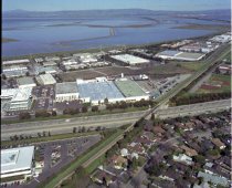
Bohannon Industrial Park in Menlo Park, 1990 - Negative
Bohannon Industrial Park in Menlo Park, 1990. Color negative shows an aerial view of the Bohannon Industrial Park in Menlo Park, California east of the Bayshore Freeway (Highway 101). The Freeway runs from left to right in the image. Intersecting over the top of the freeway near center are the Southern Pacific Railroad tracks, which run from bottom left to upper right. Part of a series. See also 2015.001.23312 series.
Record Type: Photo
-
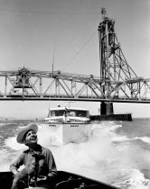
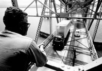
Bridge Operator Monitoring Traffic on the San-Mateo Hayward Drawbridge, 1962 - Negative
Bridge Operator Monitoring Traffic on the San-Mateo Hayward Drawbridge, 1962. Black and white negative shows a bridge operator monitoring automotive and maritime traffic on the 1929 San Mateo-Hayward Drawbridge. The operator's back is to the camera and he looks down to monitor traffic driving on the bridge below. He wears glasses and rests his arms on a railing. The metal trusses of the bridge are visible and surrounding them is the San Francisco...
Record Type: Photo
-
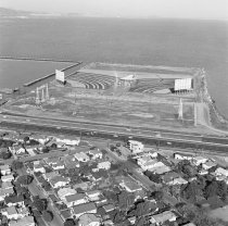
Burlingame and Peninsula Drive-in Theaters, 1965 - Negative
Burlingame and Peninsula Drive-in Theaters, 1965. Black and white negative of Burlingame and Peninsula Drive-In Theaters at the Anza Park Development looking east toward San Francisco Bay. There are two theaters (the Burlingame Drive-In Theater and the Peninsula Drive-In Theater) on a square strip of land. Both screens face the San Francisco Bay. Halfway between the screens is a domed building. Part of a series. See also 08151 and 09590.
Record Type: Photo
-
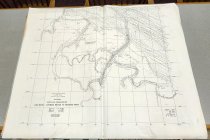
California, South San Francisco Bay, San Mateo–Hayward Bridge to Redwood Point - Map
California, South San Francisco Bay, San Mateo–Hayward Bridge to Redwood Point by the U. S. Coast and Geodetic Survey, 1956. Inscription at bottom left reads, "U. S. COAST AND GEODETIC SURVEY / H. A. KARO, Director / HYDROGRAPHIC SURVEY No. 8275 / CALIFORNIA / SOUTH SAN FRANCISCO BAY / SAN MATEO – HAYWARD BRIDGE TO REDWOOD POINT / Date of Survey….Jan.-Mar, 1956 / Scale…1 : 10,000 / Chief of Party…H. G. Conerly / Surveyed by H. G...
Record Type: Archive
-
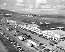
Cargo Terminals at SFO, 1958 - Negative
Cargo Terminals at SFO, 1958. Black and white negative of the original terminals at San Francisco International Airport (SFO). This image shows several terminals and hangars on a tarmac. Some planes are parked outside the hangars and others are taxiing on the runway. Slightly left of center in the image is the Mills Field terminal, which has been converted into a general aviation terminal with several hangars. Southwest Airways, Western Air Lines...
Record Type: Photo
-
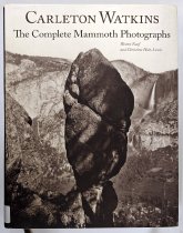
Carleton Watkins: The Complete Mammoth Photographs - Watkins, Carleton E.; Naef, Weston J.; Hult-Lewis, Christine; Von Euw, Jack; Wat
Carleton Watkins: The Complete Mammoth Photographs by Weston J. Naef, Christine Hult-Lewis, Jack Von Euw, and Jennifer A Watts, 2011. J. Paul Getty Museum, Los Angeles. Contents includes: 1. Becoming a Professional Picture Make; 2. The Great Yosemite Valley and Related Pictures; 3. San Francisco; 4. The Pacific Coast; 5. South, East, and North of San Francisco Bay; 6. The California Missions Project; 7. Picturing the Topographical Landscape; 8. R...
Record Type: Library