
Archive Record
Images
Metadata
Title |
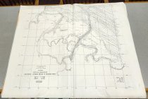
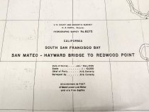
California, South San Francisco Bay, San Mateo–Hayward Bridge to Redwood Point |
Object Name |
Map |
Scope & Content |
California, South San Francisco Bay, San Mateo–Hayward Bridge to Redwood Point by the U. S. Coast and Geodetic Survey, 1956. Inscription at bottom left reads, "U. S. COAST AND GEODETIC SURVEY / H. A. KARO, Director / HYDROGRAPHIC SURVEY No. 8275 / CALIFORNIA / SOUTH SAN FRANCISCO BAY / SAN MATEO – HAYWARD BRIDGE TO REDWOOD POINT / Date of Survey….Jan.-Mar, 1956 / Scale…1 : 10,000 / Chief of Party…H. G. Conerly / Surveyed by H. G. Conerly / SOUNDINGS IN FEET / at Mean Lower Low Water / and are true depths." Printed with black ink on white paper. Scale 1:10,000. Dimentions: 36.75" x 42.375" |
Date |
1956 |
Creator |
United States Coast and Geodetic Survey |
Catalog Number |
2022.035.012 |
Collection |
Archival - Maps |
Search Terms |
Navigation San Francisco Bay |
Subjects |
San Francisco Bay Area Topographic maps |
Credit line |
Courtesy of Paula Uccelli |