
Photo Record
Images
Metadata
Title |
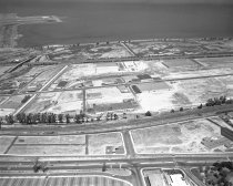
Aerial View of Ingold-Milldale Neighborhood in Burlingame, 1957 |
Object Name |
Negative |
Description |
Aerial View of Ingold-Milldale Neighborhood in Burlingame, 1957. Black and white negative of the Ingold-Milldale neighborhood in Burlingame looking east towards the San Francisco Bay. El Camino Real is in the lower foreground of the image and Trousdale Drive is below it. California Drive and the Southern Pacific Railroad tracks can also be seen in the center. The Guittard Chocolate Factory is situated along the railroad tracks. The Bayshore Freeway (Highway 101) cuts across the photograph near the top. Runways at San Francisco International Airport can be seen at top left. |
Date |
1957 |
Photographer |
Pearl, Norton |
Studio |
Norton Pearl Photography |
Catalog Number |
2015.001.00707.1 |
Collection |
Archival Collection |
Category |
Photographs |
Place |
Burlingame, CA |
Subjects |
Aerial photographs Bays Food industry Railroad tracks Roads Salt industry Salt mining Landscape photographs |
Search Terms |
Aerial Views Burlingame El Camino Real (CA-82) Guittard Chocolate Co. Highway 101 (US 101) Landscapes San Francisco Bay San Francisco International Airport (SFO) Southern Pacific Southern Pacific Railroad |
Copyright |
Norton Pearl Photography / San Mateo County Historical Association |
Credit line |
Norton Pearl Collection/San Mateo County History Museum |