
Search Term Record
Metadata
Name |
Port of Redwood City |
Number of Archive records |
3 |
Number of Object records |
10 |
Number of Photo records |
24 |
Number of Library records |
3 |
Related Records
-
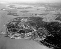
Aerial of Brewer Island (Foster City), 1962 - Negative
Black and white negative shows an aerial view looking south of Brewer Island under development to become Foster City. Brewer Island appears at center with undeveloped Redwood Shores, Bair Island, and the Port of Redwood City in the distance above center. The San Carlos Airport is visible at upper right.
Record Type: Photo
-
Aerial View of Frank's Tannery and Port of Redwood City, August 1958 - Negative
Aerial View of Frank's Tannery and Port of Redwood City, August 1958. Black and white negative shows an aerial view of the Port of Redwood City. Veteran's Boulevard is in the lower center right of the image. Bayshore Freeway (Highway 101) runs through the center of the photograph. Frank's Tannery can be seen in the center of the image. Leslie Salt Company is visible in the upper left.The Port of Redwood City is in the upper left background with t...
Record Type: Photo
-
Aerial View of Frank's Tannery and Port of Redwood City, August 1958 - Negative
Aerial View of Frank's Tannery and Port of Redwood City, August 1958. Black and white negative shows an aerial view of the Port of Redwood City with Frank's Tannery in the center of the image. The tannery consists of a cluster of buildings, mostly long single-story structures. There is one larger structure in the center with a water tower, smokestack, and another tower. The Bayshore Freeway (Highway 101) is visible to the left of the Tannery. T...
Record Type: Photo
-
Aerial View of Port of Redwood City Looking Southeast, August 1958 - Negative
Aerial View of Port of Redwood City Looking Southeast, August 1958. Redwood Creek can be seen in the center of the image with a Leslie Salt Company platform extracting salt. More salt ponds are in the upper right of the photograph. The Port of Redwood City and Pacific-Portland Cement Plant (now known as Cemex) are visible at upper left. The San Francisco Bay appears in the background along the top of the image. Part of a series of 15.
Record Type: Photo
-
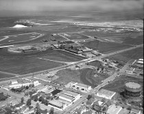
Aerial View of San Carlos Industrial Area, 1967 - Negative
Aerial View of San Carlos Industrial Area, 1967. Black and white negative shows an aerial view of San Carlos industrial area looking northeast. El Camino, the Southern Pacific Railroad, and Old County Road can be seen in the middle of the image and run left to right. Brittan Avenue runs from lower left to the Bayshore Freeway (Highway 101). Bair Island appears at the top of the photograph.
Record Type: Photo
-
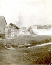
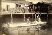
Canoe Club, Redwood City, c. 1880-1890 - Print, Photographic
Three canoes, with a man, two children, and a women in them, in a narrow channel - possibly Redwood Creek adjacent to the port. A lattice-work boathouse is behind the stream, with wooden steps leading to the water. "[B?ll] Canoe Club" is lettered on the boathouse. To the right of the boathouse, and farther back, is a larger boat out of the water and resting at an angle sloping toward the camera. Another child is posing on this boat. To the r...
Record Type: Photo
-
Celebrate Redwood City 150: 1867-2017 - McGovern, Janet
Celebrate Redwood City 150: 1867-2017, Edited by Janet McGovern, 2017. The Redwood City Sesquicentennial Celebration Committee, Redwood City. A special edition magazine celebrating Redwood City's Sesquicentennial. The magazine includes multiple articles with color photography on topics such as early pioneers, local government, transportation, business and industry, education, religious organizations, and sports.
Record Type: Library

-
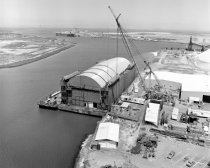
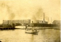
Hughes Mining Barge at the Port of Redwood City, 1980 - Negative
Black and white photo negative aerial of Port of Redwood City. Part of a series. This aerial depicts a barge built by Howard Hughes to conceal his latest secret project. Part of a series of Port of Redwood City and industry. Description provided by the photographer, Norton Pearl, with assistance from project organizer Cynthia Schreurs Hughes Mining Barge at the Port of Redwood City, 1980. Black and white negative shows an aerial view of th...
Record Type: Photo
-
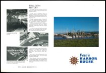
Pete's Harbor House - Ad, Print
Pete's Harbor House, c. 1973-2002. Print advertisement for the restaurant Pete's Harbor House; offset lithograph on white paper. A color image of a building near the water with boats docked in front appears on the right side of the page. The left side contains three black and white images with accompanying text on the history of Pete's Harbor. A graphic of a brown ship's wheel and "Pete's / Harbor / House" in large blue font appear at lower r...
Record Type: Archive
-
Port of Redwood City, 1896 - Painting
Port of Redwood City, 1896 by Fred Sinclair, Jr., 2015. Acrylic and oil on 4'x4' canvas completed April 2015.
Record Type: Object
-
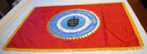
Port of Redwood City Banner, c. 1970-1980 - Banner
Port of Redwood City Banner, c. 1970-1980. Banner is rectangular in shape, with horizontal edge being the longer edge. Background is red with gold fringe. In center is a circular design. Working from center out: There is a black ship on blue water and in the center of the ship it reads "Port of / Redwood / City" in white text. Around this is a white porthole. Around that is a dark blue border with gold text that reads "Board of Port Commissio...
Record Type: Object
-
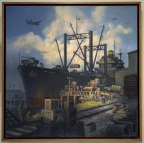
Port of Redwood City During World War II - Painting
Port of Redwood City During World War II by Fred Sinclair, Jr., 2015. Acrylic and oil on 4'x4' canvas by Fred Sinclair, Jr., completed April 2015.
Record Type: Object
-
Port of Redwood City Looking Southeast, August 1958 - Negative
Port of Redwood City Looking Southeast, August 1958. Black and white negative showing an aerial view of the Port of Redwood City looking southeast. The Leslie Salt ponds appear in the lower right and left of the photograph. Redwood Creek is visible at center. To the left of the Port is the Pacific-Portland Cement Plant, now known as Cemex. Greco Island is to left of the cement plant. The San Francisco Bay and Fremont Hills are visible in the back...
Record Type: Photo
-
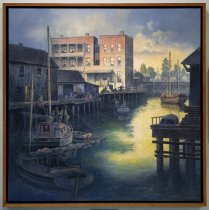
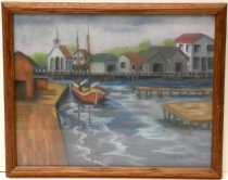
Redwood City Harbor by Marjorie Fried - Painting
Oil Pastel painting of Redwood City Harbor by Marjorie Fried. Mounted under glass in a reddish-brown wooden frame. Image depicts two docks coming out from the right edge and another dock with a red structure extending the length of the left edge. A red two-masted sailboat is alongside the left dock with its sails down. In the background is a boardwalk behind which is a church and several buildings with red and green roofs.
Record Type: Object
-
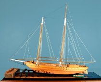
Regina "S" Model Ship by Charles Parsons - Model, Instructional
Regina "S" Model Ship by Charles Parsons at 1:32 scale. Wooden ship is a 2 masted sailing ship, but sails are not up. There is one deck, and the right edge is incomplete. There is a wheel at the rear to turn the sails. Also at the rear is a built up "box" with an incomplete roof. The center of the deck also has a raised rectangular section with an incomplete roof. There are two, black anchors at front of ship. Each side of front reads "REGINA S" ...
Record Type: Object
-
Rowboat in Turning Basin, Redwood City - Print, Photographic
Rowboat in Turning Basin, Redwood City, c. 1880-1890. Man rowing a boat with two women riding. The boat has the hull shape of a canoe with two pointed ends, but is configured as a rowboat with oars. "Lilian" is lettered on the boat. Five men are posing on the dock behind the boat. There is a stack of material, possibly brick, on the dock. here is an unidentified commercial building behind the dock, and one or two sheds to the right on the do...
Record Type: Photo
-
San Carlos Hills, 1964 - Negative
Black and white photonegative of San Carlos Hills looking east. Port of Redwood City, undeveloped Redwood Shores, and Leslie Salt Pile in center background. Mt. Diablo in upper center background. Part of a series. Description provided by the photographer, Norton Pearl, with assistance from project organizer Cynthia Schreurs.
Record Type: Photo
-
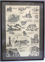
Scenes from across San Mateo County by Ken Paul, c. July-August 1981 - Drawing
Scenes from across San Mateo County by Ken Paul, c. July-August 1981. Signed framed artwork by local artist Ken Paul. Purchased by donor over 20 years ago for her husband's office. This piece of artwork is encased in a burgundy frame with a gray mat glass made of acyclic plastic over a white background with engravings. On the painting, there are various pictures and scenes engraved onto the painting. On the far top left hand corner, there is a en...
Record Type: Object
-
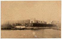
Shingle Barge at Tacoma Mill Company - Print, Photographic
Shingle Barge at Tacoma Mill Company, c. 1880-1890. Black and white photograph shows about a dozen men standing on a barge stacked with wooden shingles. The photograph is taken from the water looking back to where the barge is docked near the Tacoma Mill Company, a large single-story rectangular building. Several men appear in a small boat near the barge left of center, and stacks of shingles and other supplies appear next to them on shore.
Record Type: Photo
-
Shingle Barge at Tacoma Mill Company, c. 1880-1890 - Print, Photographic
Shingle Barge at Tacoma Mill Company, c. 1880-1890. Photograph is also identified by an accompanyng note "Redwood Creek at Bradford Street."
Record Type: Photo
-
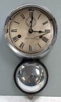
Ship Bell Clock, c. 1910 - Clock, Ship's
Silver colored brass metal clock with bell beneath that chimes every 30 minutes. Silver colored brass face has black hands, Roman numerals and a second hand clock beneath XII. Wood backing has original label behind clock and Peninsula Clock Shop, San Mateo sticker behind bell. Loose key and washer. Silver colored metal mounting brackets attached to back at top and bottom. "SETH THOMAS" printed on face. Strike lever on left still rings bell ...
Record Type: Object
-
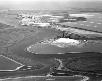
Untitled [Leslie Salt Company Aerial View] - Photograph, Color
Untitled [Leslie Salt Company Aerial View], c. mid 1970s - early 1980s. Color photograph shows an eastward aerial view of the Leslie Salt Company loading dock and operations facility in the Port of Redwood City. A large salt mountain appears in the foreground, and the Hughes Mining Barge can be seen above center in the near distance.
Record Type: Photo
![Untitled [Leslie Salt Company Aerial View], c. mid 1970s - early 1980s](https://s3.amazonaws.com/pastperfectonline/images/museum_136/054/thumbs/2022035008.jpg)
-
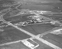
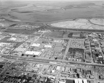
Untitled [Northeast Port of Redwood City Aerial View] - Photograph, Black-and-White
Untitled [Northeast Port of Redwood City Aerial View], c. 1958-1968. Black and white photograph shows a northeast aerial view of the Port of Redwood City. Veterans Boulevard appears from left to right along the lower margin of the image and the Bayshore Freeway crosses the image at center. Frank's Tannery appears at center right, and Pete's Harbor can be seen at upper left. Leslie Salt Company facilities appear at top center. "Hatfield Aerial Sur...
Record Type: Photo
![Untitled [Northeast Port of Redwood City Aerial View], c. 1958-1968](https://s3.amazonaws.com/pastperfectonline/images/museum_136/054/thumbs/2022035004.jpg)
-
Untitled [Northwest Port of Redwood City Aerial View] - Photograph, Black-and-White
Untitled [Northwest Port of Redwood City Aerial View], c. 1958-1968. Black and white photograph shows a northwest aerial view of the Port of Redwood City. Bair Island fills the center of the image with the Bayshore Freeway visible along the left and lower left-hand side. Leslie Salt Company facilities and Pete's Harbor appear at bottom center. "Hatfield Aerial Surveys / 274 Leland Avenue / Menlo Park, DA 2-8805" is embossed on the bottom righ...
Record Type: Photo
![Untitled [Northwest Port of Redwood City Aerial View], c. 1958-1968](https://s3.amazonaws.com/pastperfectonline/images/museum_136/054/thumbs/2022035005.jpg)
-
Untitled [Pete’s Harbor Aerial View] - Photograph, Black-and-White
Untitled [Pete's Harbor Aerial View], July 1, 1986. Black and white photograph shows an overhead view of Pete's Harbor in the Port of Redwood City. Multiple boats are docked in the harbor. Harbor House is visible above center in the image; the rooftop is painted with "PETE'S HARBOR" in large letters. The area where Redwood Creek meets Smith Slough appears at right. An inscription stamped on the back reads, "AERIAL DATA SYSTEMS / 1127 Gray Ave. ...
Record Type: Photo
![Untitled [Pete's Harbor Aerial View], July 1, 1986](https://s3.amazonaws.com/pastperfectonline/images/museum_136/054/thumbs/2022035007.jpg)