Search Term Record
Metadata
Name |
Foster City |
Number of Archive records |
32 |
Number of Object records |
6 |
Number of Photo records |
27 |
Number of Library records |
9 |
Related Records
-
04-SM-92-7.2-14.2 - South Norfolk Street to Toll Plaza, Hayward-San Mateo Bridge - Document File
04-SM-92-7.2-14.2 - South Norfolk Street to Toll Plaza, Hayward-San Mateo Bridge, 1965. Right of way acquisition documents for parcels of land in San Mateo County. This file includes historical background on the beginnings of Foster City. Appraised parcels belong to T. Jack Foster and Sons with the exception of one owned by the Henry Mitvalsky Estate. The properties were needed to create a bridge and roadway from South Norfolk Street in San Mateo...
Record Type: Archive

-
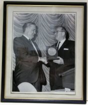
1964 Photograph of T. Jack Foster Receiving Annual Horatio Alger Award - Photograph
1964 Photograph of T. Jack Foster Receiving Annual Horatio Alger Award. Black and white 8x10 photograph is mounted under glass beneath a white paper mat, with an inner border comprised of two black lines, inside a painted black metal frame with a gold colored inner border. Image depicts Foster, wearing a dark suit and tie with a white collared shirt, shaking hands with another gentleman, also in a dark suit and tie. The second figure is standin...
Record Type: Object
-
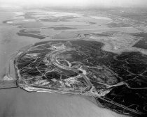
Aerial, Beginning Development of Brewer Island into Foster City, 1961 - Negative
Black and white negative shows an aerial view looking west of the Brewer Island development into Foster City. Bay Meadows Racetrack is visible at center left, and Coyote Point appears at upper right in the image. The cities of San Mateo, Hillsborough, Burlingame, and Millbrae appear in the distance across the upper portion of the image.
Record Type: Photo
-
Aerial of Belmont and Brewer Island (Foster City) Looking Northwest, 1961 - Negative
Black and white negative shows an aerial view from Belmont looking northwest over Brewer Island as it is being developed into Foster City. Bayshore Freeway (US 101) runs vertically left of center up from the bottom of the image. Coyote Point appears left of center approximately two-thirds up the image. Steinberger Slough appears in the lower right corner.
Record Type: Photo
-
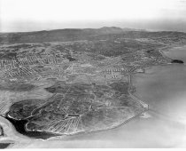
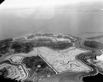
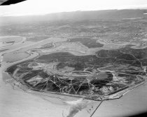
Aerial of Brewer Island (Foster City), 1962 - Negative
Black and white negative shows an aerial view looking south of Brewer Island under development to become Foster City. Brewer Island appears at center with undeveloped Redwood Shores, Bair Island, and the Port of Redwood City in the distance above center. The San Carlos Airport is visible at upper right.
Record Type: Photo
-
Aerial of Brewer Island (Foster City), San Mateo, 1962 - Negative
Aerial of Brewer Island (Foster City), San Mateo, 1962. Black and white negative shows an aerial view of Brewer Island (pre development into Foster City) looking northeast. Belmont Slough is visible at right with the Los Prados neighborhood of San Mateo visible at lower left. The 1929 San Mateo-Hayward Drawbridge is visible just above and left of center, spanning the San Francisco Bay. The bridge extends into the distance toward the upper right c...
Record Type: Photo
-
Aerial of Redwood Shores and Brewer Island Looking Northwest, 1961 - Negative
Black and white negative shows an aerial view of undeveloped Redwood Shores and Brewer Island (Foster City) looking northwest. Steinberger Slough appears in the foreground running left to right across the lower portion of the image. Belmont Channel appears nearby with the diamond-shaped Redwood Shores Lagoon visible at lower left. Brewer Island appears at center.
Record Type: Photo
-
Aerial of the College of San Mateo under Construction, 1962 - Negative
Aerial of the College of San Mateo under Construction, 1962. Black and white negative shows an aerial view of the Construction of the College of San Mateo looking northeast. Buildings that are partially constructed appear across center of the image. The city of San Mateo and Brewer Island (Foster City) are visible in the background. Part of a series.
Record Type: Photo
-
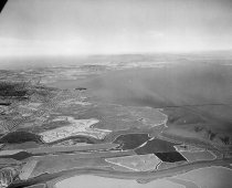
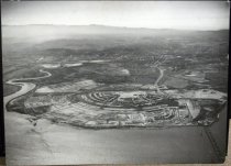
Aerial View of Brewer Island Looking Southwest, April 1962 - Negative
Aerial View of Brewer Island Looking Southwest, April 1962. Black and white negative shows an aerial view of Brewer Island looking southwest before the development of Foster City. The area consists of wetlands and a canal, with a few roads visible. Redwood Shores and Bair Island can be seen in the left of the photograph. In the background is Redwood City. Part of a series of 10.
Record Type: Photo
-
Aerial View of Foster City - Photograph
Aerial View of Foster City. Black and white photographic print on paper mounted to masonite wooden board; pine wooden cleats are mounted to back. View depicts Foster City under development. There is water in the foreground and some buildings at lower half of center peninsula and lower right of outer peninsula. The City of San Mateo can be seen in the background. In bottom right corner, vehicles are traveling over the SF Bay on Highway 92. On...
Record Type: Object
-
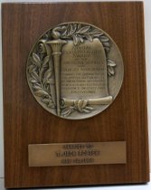
Award Plaque Honoring T. Jack Foster, 1964 - Plaque, Award
1964 Award Plaque Honoring T. Jack Foster. Wooden plaque has a clear varnish and two brass-colored pieces of metal mounted to the front. The top metal piece is round in shape and has an embossed motif of leaves, a torch and a scroll. The scroll in inscribed with text that reads, "ANNUAL / HORATIO ALGER / AWARD / OF THE / AMERICAN SCHOOLS / AND COLLEGES ASSOCIATION / TOWARDS THE ENHANCING OF / THE AMERICAN TRADITION / OF OVERCOMI...
Record Type: Object
-
Brewer Island Aerial, Beginning Development of Foster City, 1962 - Negative
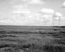
Brewer Island Aerial, Beginning Development of Foster City, 1962. Black and white negative shows Brewer Island with the early development of Foster City. Marshland with some sloughs and channels are visible in the image. The 1929 San Mateo-Hayward Drawbridge and Highway 92 extend along the lower shoreline. A transmission tower is visible to the left of center in this area. Part of a series.
Record Type: Photo
-
Brewer Island (Foster City) at Onset of Lagoon Construction Development, 1962 - Negative
Black and white negative shows Brewer Island (Foster City) at the onset of lagoon construction development, looking north. Part of a series.
Record Type: Photo
-
Development of Brewer Island into Foster City, 1956-1967 - Negative
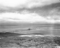
Development of Brewer Island into Foster City, 1956-1967. Black and white negative shows an aerial view of Brewer Island and the 1929 San Mateo-Hayward Drawbridge before the development of Foster City. Brewer Island is visible in the foreground along the lower portion of the image, and the drawbridge extends across the image at center. Part of a series. See also series 01771; 02643; 02887; 03037; 03974; 03820; 03078; 04283.
Record Type: Photo
-
Documents on the work of Marie Davis - Archive
Documents on the work of Marie Davis, 1964-2019. Photocopied documents compiled by Marie Davis that include biographical information, activist work, her artistic career, and awards. 2019.110.9 - Marie Davis Biography, c. 2005-2019 2019.110.10-.12 - political fliers related to campaign for seat on the Foster City Chamber of Commerce, 1993 2019.110.13 - Text of Senate Joint Resolution No. 1, Introduced by Senator Murray, January 10, 2001 201...
Record Type: Archive

-
Dredging and Construction of Lagoons for Foster City, 1962 - Negative
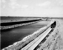
Dredging and Construction of Lagoons for Foster City, 1962. Black and white negative shows the dredging and construction of lagoons and canals for Foster City, California. One canal runs from the lower left corner of the image to the upper right. The canal wall appears to still be under construction with exposed rebar on the right bank. At the end of the canal runs through a pipe underneath an earthen bridge. On the bridge are two trucks and seve...
Record Type: Photo
-
Early Development of Brewer Island into Foster City, c. 1962-1967 - Negative
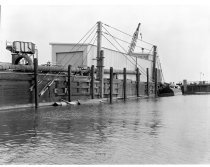
Early Development of Brewer Island into Foster City, c. 1962-1967. Black and white negative of the filling in and dredging of the canals on Brewer Island during the construction of Foster City. There is a canal to the right of the image, and a pier to the left. There are several cables and posts on the pier as well as a corrugated metal building at the center of the photograph with a large garage door and a crane. There is a large metal canister ...
Record Type: Photo
-
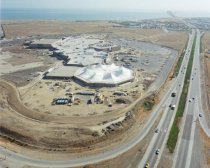
Fashion Island Construction in San Mateo, 1982 - Negative
Color photo aerial negative of Fashion Island construction with tented roof for Bloomingdale Store looking east towards San Francisco Bay. Highway 92 on right side of photo. Part of a series. Description provided by the photographer, Norton Pearl, with assistance from project organizer Cynthia Schreurs
Record Type: Photo
-
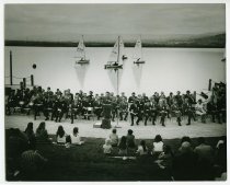
Foster City Dedication - Photograph, Black-and-White
Foster City Dedication, 1971. Black and white photograph shows the ceremony for the dedication of the Foster City near East Hillsdale Boulevard. Photographed by Robert Toren, the image shows a group of people sitting on a hillside listening to a speaker. The speaker, Ralph Lomele, stands at a podium on the boardwalk along the Foster City lagoon in front of a row of seated officials. Several sailboats appear behind them in the lagoon.
Record Type: Photo
-
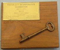
Foster City Incorporation Celebration Key - Key, Commemorative
Foster City Incorporation Celebration Key, 1971. Small plaque with a brass skeleton key affixed diagonally at bottom right. At top left corner, a rectangular metal plaque is affixed that reads, "FOSTER CITY INCORPORATION / CELEBRATION / May 8, 1971 / MAYOR / Wayne A. McFadden / Councilmen / H. James Duffelmeyer Mark S. Reeve / Ed. L. Keyser William E. Walker."
Record Type: Object
-
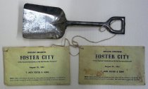
Foster City Souvenir Ground-breaking Shovel and Envelopes, 1961 - Souvenir
Foster City Souvenir Ground-breaking Shovel and Envelopes, 1961. Small silver colored metal shovel (A) has a flat edge and tapered sides and a U-shaped handle with a closed top. Envelopes (B-C) are yellow in color and both read, "GROUND BREAKING / FOSTER CITY / 'A New Bayside Community on the San Francisco Peninsula' / August 25, 1961 / T. JACK FOSTER & SONS / NOTE: When official ground breaking takes place during ceremony use shovel ...
Record Type: Object
-
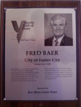
Fred Baer Sports Hall of Fame Plaque - Plaque, Award
Wood and acrylic plaque commemorating Fred Baer of Foster City who was inducted into the San Mateo County Sports Hall of Fame on June 7, 2000. Plaque includes image of Baer and a brief biography: "Fred Baer is a man for all seasons. Baer, of Foster City, has operated the authoritative California state JC Athletic Bureau for 30 years. It is the bible of sports information for all 107 two-year institutions in California. He is a national and int...
Record Type: Object
-
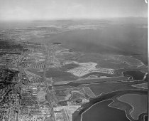
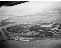
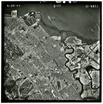
GS-VBZJ 2-77 - Photograph, Black-and-White
GS-VBZJ 2-77, April 20, 1968. Black and white aerial photograph shows an area over San Mateo and Hayward Park. North is oriented to the top of the photograph. Coyote Point appears at top left, and part of Brewer Island (Foster City) appears at lower right. Bay Meadows racetrack is visible at bottom center and the Peninsula Golf and Country Club appears at bottom left. Flight by the United States Geological Survey (USGS). An inscription in the ri...
Record Type: Photo
-
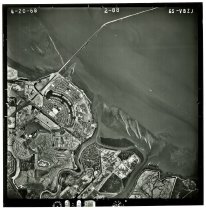
GS-VBZJ 2-88 - Photograph, Black-and-White
GS-VBZJ 2-88, April 20, 1968. Black and white aerial photograph shows an area with parts of Brewer Island (Foster City), Redwood Shores, and the San Mateo-Hayward Bridge. North is oriented to the top of the photograph. Flight by the United States Geological Survey (USGS). An inscription in the right-hand margin indicates the original negative was shot on Kodak Safety film. 9.5" x 9.5" gelatin silver print.
Record Type: Photo
-
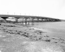
Hillsdale Boulevard Bridge to Brewer Island (Foster City), 1962 - Negative
Hillsdale Boulevard Bridge to Brewer Island (Foster City), 1962. Black and white negative shows the Hillsdale Boulevard Bridge looking north toward Brewer Island (Foster City). The photograph was taken from the bank of Seal slough with the bridge visible in the upper portion of the image. Part of a series.
Record Type: Photo