
Photo Record
Images
Metadata
Title |
GS-VBZJ 2-77 |
Object Name |
Photograph, Black-and-White |
Description |
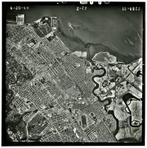
GS-VBZJ 2-77, April 20, 1968. Black and white aerial photograph shows an area over San Mateo and Hayward Park. North is oriented to the top of the photograph. Coyote Point appears at top left, and part of Brewer Island (Foster City) appears at lower right. Bay Meadows racetrack is visible at bottom center and the Peninsula Golf and Country Club appears at bottom left. Flight by the United States Geological Survey (USGS). An inscription in the right-hand margin indicates the original negative was shot on Kodak Safety film. 9.5" x 9.5" gelatin silver print. |
Date |
April 20, 1968 |
Processing Method |
Gelatin Silver Print |
Catalog Number |
2023.050.009 |
Dimension Details |
9.5" x 9.5" |
Collection |
Archival - Photographs |
Place |
San Mateo, CA//Hayward Park, CA/Foster City, CA |
Inscriptions |
"4 – 20 – 68" (in negative, top left); "2-77" (in negative, top center); GS – VBZJ" (in negative, top right); "KODAK SAFETY FILM" (in negative, repeated along right edge); "[0008]" (in negative, center right); additional inscriptions in negative partially visible along top edge at center. |
Notes |
See: https://www.lib.berkeley.edu/EART/AerialPhotos/airphotovbzj/ [accessed 09/25/2023] |
Search Terms |
Aerial Views Bay Meadows Foster City Hayward Park Peninsula Golf and Country Club San Mateo United States Geological Survey (U.S.G.S.) |
Subjects |
Aerial photographs Geological surveys |
Copyright |
Copyright unevaluated |
Credit line |
Courtesy of Rand Richards |