Search Term Record
Metadata
Name |
San Mateo |
Number of Archive records |
218 |
Number of Object records |
131 |
Number of Photo records |
498 |
Number of Library records |
50 |
Related Records
-
Print, Photographic
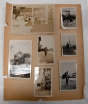
Photos Removed From Joseph Dutilh WWII Scrapbook, Page 1, 1944. Page contains seven black-and-white photographs; six are of Joseph Dutilh in front of various buildings and landmarks such as the Eiffel Tower, and one is of several people in San Mateo's Peninsula French Laundry.
Record Type: Archive
-
04-SM-101-11.1; Widen E. Hillsdale Blvd. and relocate Southbound on-ramp to 101. - Document File
04-SM-101-11.1; Widen E. Hillsdale Blvd. and relocate Southbound on-ramp to 101, 1966-1969. Right of way acquisition documents for parcels of land in San Mateo County. This file concerns one parcel needed to widen Hillsdale Boulevard to accommodate an off-ramp onto Highway 101.
Record Type: Archive

-
04-SM-101-5.6-12.2; From Harbor Blvd. in Redwood City to 0.4 Mi. N. Rte. 92 in San Mateo. - Document File
04-SM-101-5.6-12.2; From Harbor Blvd. in Redwood City to 0.4 Mi. N. Rte. 92 in San Mateo, 1969. Right of way acquisition documents for parcels of land in San Mateo County. This file shows three parcels needed for the 19th Avenue and Bayshore interchange project in San Mateo.
Record Type: Archive

-
04-SM-280-5.6X-12.8X; Raymundo Drive to San Mateo Creek Bridge. - Document File
1-04-SM-280-5.6X-12.8X; Raymundo Drive to San Mateo Creek Bridge, 1965-1975. Right of way acquisition documents for parcels of land in San Mateo County. This file shows four parcels between West Hillsdale and Polhemus Drive needed for residential development.
Record Type: Archive

-
04-SM-280-X5.6-R12.6 - Raymundo Dr. to S. end of San Mateo Creek Bridge - Document File
04-SM-280-X5.6-R12.6 - Raymundo Dr. to S. end of San Mateo Creek Bridge, 1967-1968. Right of way acquisition documents for parcels of land in San Mateo County. This file shows Belmont and San Mateo properties needed for construction of Highway 92 in the vicinity of Ralston Avenue and Polhemus Road.
Record Type: Archive

-
04-SM-92-11.6-13.1; S. Delaware St. in San Mateo to 0.7 mi. E. of Norfolk St. - Document File
04-SM-92-11.6-13.1; S. Delaware St. in San Mateo to 0.7 mi. E. of Norfolk St., 1969-1973. Right of way acquisition documents for parcels of land in San Mateo County. This file concerns four parcels needed for the southeast quadrant of the 19th Avenue and Bayshore interchange project in San Mateo.
Record Type: Archive

-
04-SM-92-7.2-14.2 - South Norfolk Street to Toll Plaza, Hayward-San Mateo Bridge - Document File
04-SM-92-7.2-14.2 - South Norfolk Street to Toll Plaza, Hayward-San Mateo Bridge, 1965. Right of way acquisition documents for parcels of land in San Mateo County. This file includes historical background on the beginnings of Foster City. Appraised parcels belong to T. Jack Foster and Sons with the exception of one owned by the Henry Mitvalsky Estate. The properties were needed to create a bridge and roadway from South Norfolk Street in San Mateo...
Record Type: Archive

-
04-SM-92-A11.6-13.1 - South of Delaware St. in San Mateo to 0.7 mi. east of Norfolk St. - Document File
04-SM-92-A11.6-13.1 - South of Delaware St. in San Mateo to 0.7 mi. east of Norfolk St., 1969-1971. Right of way acquisition documents for parcels of land in San Mateo County. This file includes one parcel owned by the Mitvalsky family needed for the 19th Avenue and Bayshore interchange. The property was located on the southwest side of the project. Several renters were affected including: the Carnation Company; the Federal Aviation Administratio...
Record Type: Archive

-
04-SM-92-R11.6/11.6-12.4/13.1; South of Delaware St. in San Mateo to 0.7 mi. east of Norfolk St. - Document File
04-SM-92-R11.6/11.6-12.4/13.1; South of Delaware St. in San Mateo to 0.7 mi. east of Norfolk St, 1969-1970. Right of way acquisition documents for parcels of land in San Mateo County. This file concerns one parcel needed for the 19th Avenue and Bayshore interchange project in San Mateo.
Record Type: Archive

-
04-SM-92-R11.6-X12.4 - S of Delaware St in San Mateo to 0.7 Mi E of Norfolk St - Document File
04-SM-92-R11.6-X12.4 - S of Delaware St in San Mateo to 0.7 Mi E of Norfolk St, 1968. Right of way acquisition documents for parcels of land in San Mateo County. This file centers on a parcel located on the northwest side of the 19th Avenue interchange at Bayshore Freeway. The property belonged to Concar Ranch & Enterprises, Inc. owned by Laurence C. Smith. The prominent business in the area was the Unimart Discount Store on an 11-acre site that ...
Record Type: Archive
-
04-SM-92-R11.6-X13.1; S. of Delaware St. in San Mateo to 0.7 Mi. E. of Norfolk St. - Document File
04-SM-92-R11.6-X13.1; S. of Delaware St. in San Mateo to 0.7 Mi. E. of Norfolk St, 1969-1970. Right of way acquisition documents for parcels of land in San Mateo County. This file concerns one parcel needed for the 19th Avenue and Bayshore Interchange project in San Mateo.
Record Type: Archive

-
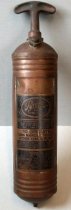
1917 Pyrene Fire Extinguisher - Extinguisher, Fire
1917 Pyrene Fire Extinguisher. Brass(?) metal fire extinguisher is cylindrical in shape with a tiny opening and bottom and what appears to be a pressure valve and T-shaped pump handle at top. Black label on front reads, "Pyrene / FIRE / EXTINGUISHER / ... / TO OPERATE / TURN HANDLE TO LEFT / WORK LIKE A PUMP." Directions indicate that, once used, pump should immediately be filled with Pyrene liquid. There is a loop bracket mounted ...
Record Type: Object
-
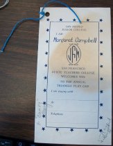
1933 Annual Triangle Play-Day in San Francisco Program - Program
San Mateo Jr. College 1933 Annual Triangle Play-Day in San Francisco Program. Off-white rectangular piece of paper folded in half to form a booklet. Hole punched in upper left corner with a piece of blue string tied through it. Printed blue-outlined smaller rectangle on cover. Smaller rectangle is surrounded by printed blue stars. Text on cover and in booklet is navy blue. Interior outlines program for Friday 13, 1933 Annual Triangle Play-Day in...
Record Type: Archive
-
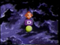
3DO Demo Tape Final - VHS
3DO Demo Tape Final, January 28, 1993. VHS video tape (A) contains a compilation of marketing videos on the 3DO Interactive Multiplayer, a home video console system. (B) business card for Trip Hawlins; (C) original paper label. Video recorded on one 3M T-60 VHS video tape; total time 00:31:30. Contents of video tape: 00:00:21-00:09:14 - Demo of the 3DO Interactive Multiplayer showing the graphic capabilities of the system. 00:09:15-00:10:19 – ...
Record Type: Archive
-
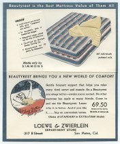
Advertisements for Loewe & Zwierlein Department Store - Advertisement
Four color prints and two mailing envelopes produced by Loewe & Zwierlein to advertise their department store in San Mateo. 2019.39.1 Advertisement for Beautyrest mattress 3.375" x 5.875" folded; 6.875" x 5.875" unfolded 2019.39.2 Advertisement for Lee Mar blouses with mail order form 6.875" x 4.25" folded; 6.875" x 9.875" unfolded 2019.39.3 Advertisement for Teena Paige Fashions with mail order form 3" x 5.875" folded; 11.75" x 1...
Record Type: Archive
-
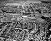
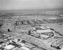
Aerial Looking East of South San Mateo - Negative
Aerial Looking East of South San Mateo, 1958. Black and white negative shows an aerial of South San Mateo looking east. Hillsdale Shopping Center appears in the center of the photograph with West Hillsdale Boulevard running from lower right through center to top center. Bay Meadows racetrack is visible at upper left.
Record Type: Photo
-
Aerial of Downtown San Mateo Looking Southeast - Negative
Black and white negative shows an aerial of downtown San Mateo looking southeast from "the Mounds." Casa Baywood Apartment building appears at center right. South El Camino Real runs from the lower left side of the image through center to the upper right. The Benjamin Franklin Hotel is visible at center left on East 3rd Avenue.
Record Type: Photo
-
Aerial of Downtown San Mateo Looking Southwest, 1962 - Negative
Black and white negative shows an aerial view of downtown San Mateo looking southwest. The baseball field in Central Park is visible left of center. 5th Avenue runs from lower right up along the right side of the baseball diamond to the upper left corner of the image.
Record Type: Photo
-
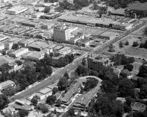
Aerial of Downtown San Mateo Looking West, 1962 - Negative
Black and white negative shows an aerial view of downtown San Mateo looking west. Central Park fills the lower left side of the image. The Levy Brothers Department Store is visible at lower right on 4th Avenue. El Camino Real appears at center left and runs above Central Park toward the upper right corner of the image. Benjamin Franklin Hotel is visible right of center on 3rd Avenue.
Record Type: Photo
-
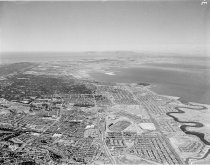
Aerial of San Mateo, 1962 - Negative
Aerial of San Mateo, 1962. Black and white aerial view shows the city of San Mateo looking northwest. San Mateo Village is visible in the foreground of the image at right. El Camino Real runs vertically up through the center of the image. Bay Meadows racetrack appears just below center. Coyote Point appears above center in the distance.
Record Type: Photo
-
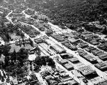
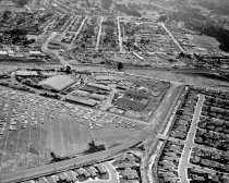
Aerial of San Mateo County Fairgrounds Looking North, 1961 - Negative
Black and white negative shows an aerial view of the San Mateo County Fairgrounds looking north. Southern Pacific train tracks are visible at lower right and run diagonally up to center left in the image. Delaware Street runs right to left in front of the fairgrounds.
Record Type: Photo
-
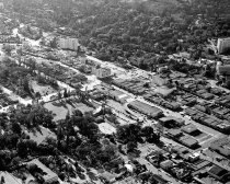
Aerial of San Mateo County Fairgrounds Looking West, 1961 - Negative
Black and white negative shows an aerial view of the San Mateo County Fairgrounds looking west. The Fiesta Gardens neighborhood is visible on the right side of the photo. Saratoga Drive runs from the bottom left corner in a curve up to center right in the image.
Record Type: Photo
-
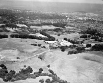
Aerial of San Mateo Hills and City of San Mateo Looking North - Negative
Black and white negative shows an aerial of the San Mateo hills before the College of San Mateo was built, looking north towards downtown San Mateo. The Peninsula Golf and Country Club golf course is visible at center right. Coyote Point appears at upper right with the San Francisco Bay in the distance.
Record Type: Photo
-
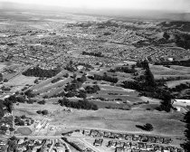
Aerial of San Mateo Hills and City of San Mateo Looking South - Negative
Black and white negative shows an aerial view of San Mateo looking south. The Peninsula Golf and Country Club with its golf course is visible at center. Alameda de las Pulgas runs from center left up through the center of the photo. Serra High School appears at center left. Hillsdale High School appears in the upper portion of the image.
Record Type: Photo
-
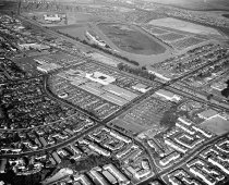
Aerial of South San Mateo Looking North with Hillsdale, Bay Meadows, and San Mateo Fair Grounds - Negative
Aerial of South San Mateo Looking North with Hillsdale, Bay Meadows, and San Mateo Fair Grounds, August 1, 1958. Black and white negative shows an aerial view of South San Mateo looking north. Hillsdale Shopping Center appears at center with El Camino Real running diagonally across the image just behind the shopping center. Bay Meadows racetrack is visible just right of center in the upper portion of the image.
Record Type: Photo