Search Term Record
Metadata
Name |
San Francisco Peninsula |
Number of Archive records |
6 |
Number of Object records |
1 |
Number of Photo records |
1 |
Number of Library records |
0 |
Related Records
-
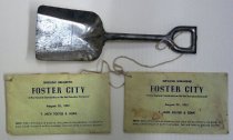
Foster City Souvenir Ground-breaking Shovel and Envelopes, 1961 - Souvenir
Foster City Souvenir Ground-breaking Shovel and Envelopes, 1961. Small silver colored metal shovel (A) has a flat edge and tapered sides and a U-shaped handle with a closed top. Envelopes (B-C) are yellow in color and both read, "GROUND BREAKING / FOSTER CITY / 'A New Bayside Community on the San Francisco Peninsula' / August 25, 1961 / T. JACK FOSTER & SONS / NOTE: When official ground breaking takes place during ceremony use shovel ...
Record Type: Object
-
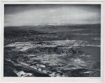
From 12,000 Feet Up - Lithograph
From 12,000 Feet Up, January 1949. Black and white print of an aerial photograph taken by Barney Peterson for the Chronicle Publishing Company. The image shows the San Francisco Peninsula with Mount Shasta visible in the distance at the top of the image down south to the Burlingame area. 11.25" x 14.25"
Record Type: Photo
-
Guestbook - Guestbook
Guestbook, c. 1952-1955. Navy blue leather, rectangular guestbook. The guestbook has six pages of signatures spanning over a year, and contains the names, addresses, and dates of visit for each person.
Record Type: Archive

-
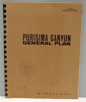
Purisima Canyon Plan Booklet, 1966 - Book
Purisima Canyon Plan Booklet, 1966. Booklet (A) by Wilsey & Ham made of sturdy taupe paper, fastened with black plastic notebook-style loops at the spine. The main 12-page part of the booklet outlines a plan for developing the Purisima Canyon area of the San Francisco Peninsula, including plans for roads, residential areas, and recreational facilities. A taupe-and-green foldout map is included showing what will go where. A 4-page appendix elabora...
Record Type: Archive
-
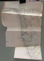
Purisima Canyon Plan Map, 1966 - Map
Purisima Canyon Plan Map, 1966. Separate black-and-white map (B) is made of three overlapping pieces of white paper, taped together, and shows the area in question in detail.
Record Type: Archive
-
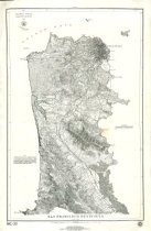
San Francisco Peninsula - Archive
San Francisco Peninsula by the U. S. Coast Survey, 1869 (1976 reprint). Coast survey map of the San Francisco Peninsula from Alcatraz Island at north to Point San Pedro at south. Includes contour lines. Inscription at top left reads, "U.S. COAST SURVEY / Benjamin Peirce Superintendent / 1869 / Verified / J.E. Hilgard / Assist Coast Survey / In Charge of Office." Graphic of a star at bottom right encircled by text that reads, "American...
Record Type: Archive
-
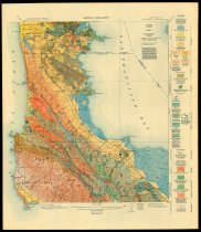
San Mateo Quadrangle, Areal Geology - Map
San Mateo Quadrangle, Areal Geology, Andrew C. Lawson, October 1913. Color geological map of the San Francisco Peninsula. "Geology by Andrew C. Lawson, assisted at various times by students of the University of California. Surveyed in 1893, 1895, 1906, and 1907." Map originally part of the Geologic Atlas of the United States, San Francisco Folio published in 1914 by the U. S. Geological Survey.
Record Type: Archive