Search Term Record
Metadata
Name |
Old County Road |
Number of Archive records |
2 |
Number of Object records |
0 |
Number of Photo records |
1 |
Number of Library records |
0 |
Related Records
-
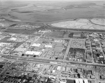
Aerial View of San Carlos Industrial Area, 1967 - Negative
Aerial View of San Carlos Industrial Area, 1967. Black and white negative shows an aerial view of San Carlos industrial area looking northeast. El Camino, the Southern Pacific Railroad, and Old County Road can be seen in the middle of the image and run left to right. Brittan Avenue runs from lower left to the Bayshore Freeway (Highway 101). Bair Island appears at the top of the photograph.
Record Type: Photo