Search Term Record
Metadata
Name |
Land Development |
Number of Archive records |
18 |
Number of Object records |
0 |
Number of Photo records |
2 |
Number of Library records |
9 |
Related Records
-
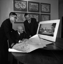
Cotton Family Looking at Renderings of Borel Place, San Mateo, January 1963 - Negative
Cotton Family Looking at Renderings of Borel Place, San Mateo, January 1963. Black and white negative shows San Mateo Superior Court Judge Aylett Cotton and family looking at renderings for the development of Borel Place in San Mateo, California. Judge Cotton sits at left in the image, facing an artist's rendering and a technical drawing of a building on a table at right. Two men stand on either side of Cotton facing the documents, including a y...
Record Type: Photo
-
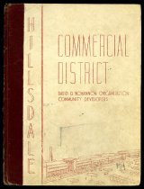
Hillsdale Commercial District - Report
Hillsdale Commercial District, 1946. Report on the viability of a proposed Hillsdale Commercial District by Planning Consultant Ronald L. Campbell for the David D. Bohannon Organization, Community Developers. The report includes information on population, economic purchasing power, transportation, and housing development in the area. Printed in black and white with multiple maps and photographs. 26 pages.
Record Type: Archive
-
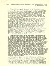
Notes on early Belmont - History
Notes on early Belmont, 1850's by Alan K. Brown. Typewritten 2-page document written in January 1959 on the residents of the area now called Belmont.
Record Type: Archive
-
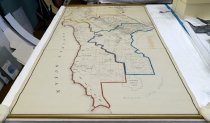
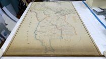
Official Map of San Mateo County California - Map
Official Map of San Mateo County California, Compiled from Official Records & Surveys by George A. Kneese, County Surveyor, 1927. San Mateo County base map with updated boundaries as of 1931 for the five Board of Supervisors' districts. Multiple handwritten notes in graphite on surface. The map also contains information on select landowners with acreages, ranchoes and school districts. Blackline and color print on paper supported with canvas. Map...
Record Type: Archive
-
Official Map of San Mateo County California - Map
Official Map of San Mateo County California, Compiled from Official Records & Surveys by George A. Kneese, County Surveyor, 1927. San Mateo County base map with boundaries of the five Board of Supervisors' districts shown in color. The map also contains information on select landowners with acreages, ranchoes and school districts. Blackline and color print on paper supported with canvas. Map attached to wooden dowel on bottom end. Scale is 1" = 2...
Record Type: Archive
-
San Francisco Bay Area: An Environmental History - Schmidt, David D.
San Francisco Bay Area: An Environmental History by David D. Schmidt, 2025. Backcountry Press, Kneeland, CA. Illustrated. PDF format; 635 pages. Description from the publisher: "San Francisco Bay Area: An environmental history by David D. Schmidt is a sweeping and richly detailed account of how one of the world's most ecologically diverse regions has been shaped over millennia by both natural forces and human hands. Beginning with the lives of ...
Record Type: Library
-
San Francisco Bay Area: An Environmental History - Schmidt, David D.
San Francisco Bay Area: An Environmental History by David D. Schmidt, 2025. Backcountry Press, Kneeland, CA. This book is about the natural environment of the San Francisco Bay Area and the history of human interaction with and development of the environment. Each chapter focuses on a particular aspect of the environment and its resources, such as fishing, logging, mining, and water, and is subdivided by county. Maps, illustrations, photographs, ...
Record Type: Library

-
Silicon Valley: The History In Pictures - Wadden, Mary
Silicon Valley: The History In Pictures by Mary Wadden, 2014. 2nd edition.
Record Type: Library

-
The Development of Foster City - Foster, T. Jack, Jr.
The Development of Foster City by T. Jack Foster, Jr., 2012. Xlibris, Bloomington, IN.
Record Type: Library
-
The Development of Foster City - Foster, T. Jack, Jr.
The Development of Foster City by T. Jack Foster, Jr., 2012. Xlibris, Bloomington, IN.
Record Type: Library