
Search Term Record
Metadata
Name |
Highway 92 (CA-92) |
Number of Archive records |
16 |
Number of Object records |
2 |
Number of Photo records |
14 |
Number of Library records |
1 |
Related Records
-
04-SM-101-5.6-12.2; From Harbor Blvd. in Redwood City to 0.4 Mi. N. Rte. 92 in San Mateo. - Document File
04-SM-101-5.6-12.2; From Harbor Blvd. in Redwood City to 0.4 Mi. N. Rte. 92 in San Mateo, 1969. Right of way acquisition documents for parcels of land in San Mateo County. This file shows three parcels needed for the 19th Avenue and Bayshore interchange project in San Mateo.
Record Type: Archive

-
04-SM-280-5.6X-12.8X; Raymundo Drive to San Mateo Creek Bridge. - Document File
1-04-SM-280-5.6X-12.8X; Raymundo Drive to San Mateo Creek Bridge, 1965-1975. Right of way acquisition documents for parcels of land in San Mateo County. This file shows four parcels between West Hillsdale and Polhemus Drive needed for residential development.
Record Type: Archive

-
04-SM-280-X5.6-R12.6 - Raymundo Dr. to S. end of San Mateo Creek Bridge - Document File
04-SM-280-X5.6-R12.6 - Raymundo Dr. to S. end of San Mateo Creek Bridge, 1967-1968. Right of way acquisition documents for parcels of land in San Mateo County. This file shows Belmont and San Mateo properties needed for construction of Highway 92 in the vicinity of Ralston Avenue and Polhemus Road.
Record Type: Archive

-
04-SM-82-9.11; Ox Mountain Road - Document File
04-SM-82-9.11; Ox Mountain Road, 1973. Right of way acquisition documents for parcels of land in San Mateo County. This file concerns one parcel needed for widening and channelization work on the intersection of Ox Mountain Road and Highway 92 (San Mateo Road) in Half Moon Bay.
Record Type: Archive

-
04-SM-92-11.6-13.1; S. Delaware St. in San Mateo to 0.7 mi. E. of Norfolk St. - Document File
04-SM-92-11.6-13.1; S. Delaware St. in San Mateo to 0.7 mi. E. of Norfolk St., 1969-1973. Right of way acquisition documents for parcels of land in San Mateo County. This file concerns four parcels needed for the southeast quadrant of the 19th Avenue and Bayshore interchange project in San Mateo.
Record Type: Archive

-
04-SM-92-7.2-14.2 - South Norfolk Street to Toll Plaza, Hayward-San Mateo Bridge - Document File
04-SM-92-7.2-14.2 - South Norfolk Street to Toll Plaza, Hayward-San Mateo Bridge, 1965. Right of way acquisition documents for parcels of land in San Mateo County. This file includes historical background on the beginnings of Foster City. Appraised parcels belong to T. Jack Foster and Sons with the exception of one owned by the Henry Mitvalsky Estate. The properties were needed to create a bridge and roadway from South Norfolk Street in San Mateo...
Record Type: Archive

-
04-SM-92-A11.6-13.1 - South of Delaware St. in San Mateo to 0.7 mi. east of Norfolk St. - Document File
04-SM-92-A11.6-13.1 - South of Delaware St. in San Mateo to 0.7 mi. east of Norfolk St., 1969-1971. Right of way acquisition documents for parcels of land in San Mateo County. This file includes one parcel owned by the Mitvalsky family needed for the 19th Avenue and Bayshore interchange. The property was located on the southwest side of the project. Several renters were affected including: the Carnation Company; the Federal Aviation Administratio...
Record Type: Archive

-
04-SM-92-R11.6/11.6-12.4/13.1; South of Delaware St. in San Mateo to 0.7 mi. east of Norfolk St. - Document File
04-SM-92-R11.6/11.6-12.4/13.1; South of Delaware St. in San Mateo to 0.7 mi. east of Norfolk St, 1969-1970. Right of way acquisition documents for parcels of land in San Mateo County. This file concerns one parcel needed for the 19th Avenue and Bayshore interchange project in San Mateo.
Record Type: Archive

-
04-SM-92-R11.6-X13.1; S. of Delaware St. in San Mateo to 0.7 Mi. E. of Norfolk St. - Document File
04-SM-92-R11.6-X13.1; S. of Delaware St. in San Mateo to 0.7 Mi. E. of Norfolk St, 1969-1970. Right of way acquisition documents for parcels of land in San Mateo County. This file concerns one parcel needed for the 19th Avenue and Bayshore Interchange project in San Mateo.
Record Type: Archive

-
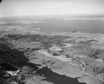
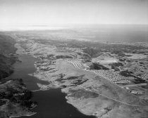
Aerial View of Crystal Springs Reservoir in San Mateo, 1961 - Negative
Aerial View of Crystal Springs Reservoir in San Mateo, 1961. Black and white negative shows an aerial view of Crystal Springs Reservoir in San Mateo. San Mateo-Half Moon Bay Road (Highway 92) crosses the reservoir. Skyline Boulevard (Highway 35) runs along right side of reservoir. Coyote Point is visible in the upper right center of the photograph, and San Francisco Bay and the East Bay are beyond that.
Record Type: Photo
-
Aerial View of Foster City - Photograph
Aerial View of Foster City. Black and white photographic print on paper mounted to masonite wooden board; pine wooden cleats are mounted to back. View depicts Foster City under development. There is water in the foreground and some buildings at lower half of center peninsula and lower right of outer peninsula. The City of San Mateo can be seen in the background. In bottom right corner, vehicles are traveling over the SF Bay on Highway 92. On...
Record Type: Object
-
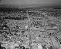
Aerial View of San Mateo, July 1963 - Negative
Aerial View of San Mateo, July 1963. Black and white negative shows an aerial view of central downtown San Mateo and south central San Mateo looking north along El Camino Real towards the J. Arthur Younger Freeway (Highway 92). The Borel Estate can be seen on the west side of El Camino Real. The Southern Pacific Railroad and Delaware Street can be seen at right in the photograph. In the background are Burlingame, Millbrae, and the San Francisco I...
Record Type: Photo
-
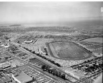
Aerial View of the City of San Mateo, 1961 - Negative
Aerial View of the City of San Mateo, 1961. Black and white negative shows an aerial view of eastern San Mateo, California, looking north. Bay Meadows racetrack can be seen at center. Highway 92 and the 1929 San Mateo-Hayward Drawbridge appear at upper right in the photograph. Hillsdale Shopping Center is in the lower left of the image. In the upper left corner of the image is Coyote Point.
Record Type: Photo
-
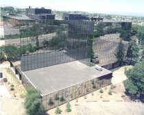
Borel Estate Offices in San Mateo, 1974 - Negative
Borel Estate Offices in San Mateo, 1974. Color negative shows the newly built office building at 411 Borel Avenue near Highway 92 in San Mateo, California. The image shows a multi-story rectangular commercial building with tinted reflective glass across the exterior. The building reflects the parking lots, trees, and roadway nearby. Part of a series.
Record Type: Photo
-
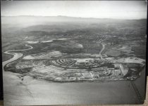
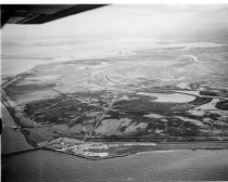
Brewer Island Aerial, Beginning Development of Foster City, 1962 - Negative
Brewer Island Aerial, Beginning Development of Foster City, 1962. Black and white negative shows Brewer Island with the early development of Foster City. Marshland with some sloughs and channels are visible in the image. The 1929 San Mateo-Hayward Drawbridge and Highway 92 extend along the lower shoreline. A transmission tower is visible to the left of center in this area. Part of a series.
Record Type: Photo
-
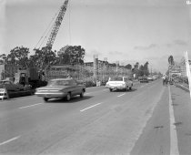
Construction of Highway 92 Overpass in San Mateo, October 1962 - Negative
Construction of Highway 92 Overpass in San Mateo, October 1962. Black and white negative shows construction of the Highway 92 overpass at El Camino Real in San Mateo, California. The image shows several cars driving along El Camino Real with construction of the overpass visible on either side of the road. A crane appears at center left lifting a large beam. Several construction workers can be seen on the scaffolding around the structure at right ...
Record Type: Photo
-
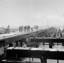
Construction of the San Francisco Bay Toll Bridge, 1963 - Negative
Construction of the San Mateo-Hayward Bridge, 1963. Black and white negative shows construction on the San Mateo-Hayward Bridge. Six people stand on the bridge at center, posing for a photograph. There are overhead power lines above and behind them, and the East Bay hills are visible on the other side of the bay. On the right side of the image, six construction workers perform various tasks. One looks through a surveying instrument mounted on a t...
Record Type: Photo
-
Crystal Springs Reservoir in San Mateo, 1960 - Negative
Crystal Springs Reservoir in San Mateo, 1960. Black and white negative shows an aerial view of Crystal Springs Reservoir and San Mateo-Half Moon Bay Road (Highway 92). The road crosses over the reservoir in the foreground. Skyline Boulevard can be seen to the right of the reservoir. The San Mateo Highlands are under development on the left of the image. San Bruno Mountain and the San Francisco Bay are visible in the background.
Record Type: Photo
-
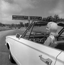
Entering 19th Avenue Freeway at Alameda de Las Pulgas, August 1963 - Negative
Entering 19th Avenue Freeway at Alameda de Las Pulgas, August 1963. Black and white photo negative of Miss San Mateo (Louisa) driving on to the new 19th Avenue Freeway (Highway) at the Alameda de Las Pulgas on ramp. Part of a series. Description provided by the photographer, Norton Pearl, with assistance from project organizer Cynthia Schreurs
Record Type: Photo
-
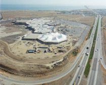
Fashion Island Construction in San Mateo, 1982 - Negative
Color photo aerial negative of Fashion Island construction with tented roof for Bloomingdale Store looking east towards San Francisco Bay. Highway 92 on right side of photo. Part of a series. Description provided by the photographer, Norton Pearl, with assistance from project organizer Cynthia Schreurs
Record Type: Photo
-
IV-SM-105-A,SM,B; San Mateo-Hayward Bridge to Jct. Rte. 55 (Ralston Ave.) - Document File
IV-SM-105-A,SM,B; San Mateo-Hayward Bridge to Jct. Rte. 55 (Ralston Ave.), 1959-1962. Right of way acquisition documents for parcels of land in San Mateo County. This file concerns two parcels needed for the 19th Avenue and El Camino Real interchange in San Mateo.
Record Type: Archive

-
IV-SM-105-A, SM, B - San Mateo-Hayward Bridge to Jct. Rte. 55 (Ralston Ave.) (Rte. 105-Mi. 1.4 B to Rte. 55-Mi. 2.1B) - Document File
IV-SM-105-A, SM, B - San Mateo-Hayward Bridge to Jct. Rte. 55 (Ralston Ave.) (Rte. 105-Mi. 1.4 B to Rte. 55-Mi. 2.1B), 1957-1958. Right of way acquisition documents for parcels of land in San Mateo County. This file concerns five properties needed for the construction of an interchange at 19th Avenue and El Camino Real in San Mateo.
Record Type: Archive

-
IV-SM-105-SM; San Mateo-Hayward Bridge to Jct. Rte. 55 (Ralston Avenue). - Document File
IV-SM-105-SM; San Mateo-Hayward Bridge to Jct. Rte. 55 (Ralston Avenue), 1957-1962. Right of way acquisition documents for parcels of land in San Mateo County. This file concerns two parcels needed to widen El Camino Real at 19th Avenue in San Mateo.
Record Type: Archive

-
IV-SM-68-SM,C,Bmt,SCar,RdwC,D,MlP; Peninsular Ave in SM (Mi. 1.91 SM) to So. Co. Boundary (Mi. 0.00D) - Document File
IV-SM-68-SM,C,Bmt,SCar,RdwC,D,MlP; Peninsular Ave in SM (Mi. 1.91 SM) to So. Co. Boundary (Mi. 0.00D), 1952-1957. Right of way acquisition documents for parcels of land in San Mateo County. This file concerns ten parcels of land needed for the future Highway 101 and Highway 92 interchange, then known as the 19th Avenue and Bayshore Bypass in San Mateo. Parcels include undeveloped land and various businesses.
Record Type: Archive

-
IV-SM-68-SM,C,Bmt,Scar,RdwC,D, Peninsular Ave. in San Mateo (Mi. 1.91 SM) to South County Boundary (Mi. 0.00D) - Document File
IV-SM-68-SM,C,Bmt,Scar,RdwC,D, Peninsular Ave. in San Mateo (Mi. 1.91 SM) to South County Boundary (Mi. 0.00D), 1953-1954. Right of way acquisition documents for parcels of land in San Mateo County. This file concerns one parcel needed for the 19th Avenue and Bayshore interchange project in San Mateo.
Record Type: Archive
