
Search Term Record
Metadata
Name |
El Camino Real (CA-82) |
Number of Archive records |
22 |
Number of Object records |
5 |
Number of Photo records |
38 |
Number of Library records |
11 |
Related Records
-
04-SM-186-X6.3-X6.9 - 0.2 Mile East of Route 280(239) to Route 82(2) in San Bruno. - Document File
04-SM-186-X6.3-X6.9 - 0.2 Mile East of Route 280(239) to Route 82(2) in San Bruno, 1965-1967. Right of way acquisition documents for parcels of land in San Mateo County. This file is concerned with building Route 186 (later I-380) through the naval base at San Bruno. Maps and photographs show the extent of the base, which ran along El Camino Real from Sneath Lane to San Bruno Avenue. The base was across the street from "the former Tanforan Race T...
Record Type: Archive

-
Aerial of Coyote Point and Old Shoreview Looking Southwest - Negative
Aerial of Coyote Point and Old Shoreview Looking Southwest, 1962. Black and white negative shows an aerial view of Coyote Point in San Mateo, California. The photograph was taken looking southwest toward the Shoreview neighborhood with the campus of the College of San Mateo visible at Coyote Point in the foreground at bottom center. The Poplar Creek Golf Course appears behind the campus. The Bayshore Freeway (US 101) runs from upper right in the...
Record Type: Photo
-
Aerial View of Coyote Point with College of San Mateo Campus, 1962 - Negative
Aerial View of Coyote Point with College of San Mateo Campus, 1962. Black and white negative shows an aerial view of Coyote Point looking south toward the Shoreview neighborhood in San Mateo, California. The College of San Mateo appears surrounded by trees at Coyote Point below center in the image with the Poplar Creek Golf Course just behind it. The Coyote Point Marina and Yacht Harbor appear to the left of the campus. The Bayshore Freeway (High...
Record Type: Photo
-
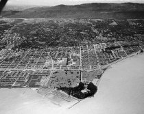
Aerial View of Downtown San Mateo, 1957 - Negative
Aerial View of Downtown San Mateo, 1957. Black and white negative showing an aerial view of downtown San Mateo from the air. Mills Hospital appears in the lower right corner. The former location of St. Matthew Catholic Church is in the lower left on San Mateo Drive and 3rd Avenue. In response to the changes made in the Second Vatican Council of 1965, St. Matthew's parish relocated to its current location on El Camino Real in 1966. San Mateo Centr...
Record Type: Photo
-
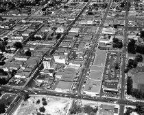
Aerial View of Downtown San Mateo, 1957 - Negative
Aerial View of Downtown San Mateo, 1957. Black and white negative of Downtown San Mateo looking east from El Camino Real (bottom of photograph). Third Avenue appears on the left side and Fifth Avenue is visible on the far right. South El Dorado Avenue is at the very top of the photograph. The Benjamin Franklin Hotel features prominently in the center. Part of a series of 12.
Record Type: Photo
-
Aerial View of Ingold-Milldale Neighborhood in Burlingame, 1957 - Negative
Aerial View of Ingold-Milldale Neighborhood in Burlingame, 1957. Black and white negative of the Ingold-Milldale neighborhood in Burlingame looking east towards the San Francisco Bay. El Camino Real is in the lower foreground of the image and Trousdale Drive is below it. California Drive and the Southern Pacific Railroad tracks can also be seen in the center. The Guittard Chocolate Factory is situated along the railroad tracks. The Bayshore Freew...
Record Type: Photo
-
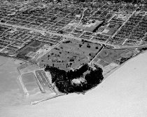
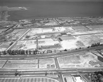
Aerial View of San Mateo County Fairgrounds and Bay Meadows Race Track, 1960 - Negative
Aerial View of San Mateo County Fairgrounds and Bay Meadows Race Track, 1960. Black and white negative showing an aerial view of the San Mateo County Fairgrounds and Bay Meadows race track looking north. A corner of the Bay Meadows race track is seen in the lower right. At the center of the image is a large parking lot full of cars. Coyote Point and the San Francisco Bay are visible in the background near the top of the photograph. Part of a seri...
Record Type: Photo
-
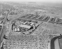
Aerial View of San Mateo County Fairgrounds and Bay Meadows Race Track, 1960 - Negative
Aerial View of San Mateo County Fairgrounds and Bay Meadows Race Track, 1960. Black and white negative shows an aerial view of the San Mateo County Fairgrounds and Bay Meadows Race Track looking south. The Southern Pacific railroad, El Camino Real, and the Bayshore Freeway are also visible. The wing of the plane the photographer is riding in appears at upper right of the image. There is a large hill in the background. Part of a series.
Record Type: Photo

-
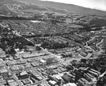
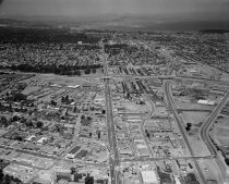
Aerial View of San Mateo, July 1963 - Negative
Aerial View of San Mateo, July 1963. Black and white negative shows an aerial view of central downtown San Mateo and south central San Mateo looking north along El Camino Real towards the J. Arthur Younger Freeway (Highway 92). The Borel Estate can be seen on the west side of El Camino Real. The Southern Pacific Railroad and Delaware Street can be seen at right in the photograph. In the background are Burlingame, Millbrae, and the San Francisco I...
Record Type: Photo
-
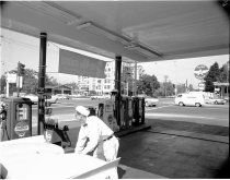
Attendant Pumps Gas at Chevron Station - Negative
Attendant Pumps Gas at Chevron Station, 1962. Black and white negative shows an attendant pumping gas at a Chevron Station on the corner of 3rd and El Camino Real in San Mateo, California. The attendant is wearing a white uniform with a white hat. He leans over the rear end of a white car that has stopped at the station. The station has a banner facing the street that reads "[FREE 49ERS SCHEDULE / Tune in on RADIO-TV]." Across the street is a F...
Record Type: Photo
-
Beautiful Burlingame - Film, Motion Picture
Beautiful Burlingame, 1937. Color silent film promotes the city of Burlingame as, "An ideal community where 20,000 people enjoy the pleasures of a suburban life in a perfect climate glorified by beautiful homes, gardens and healthful recreation." Scenes include: residential homes, apartments, and estates; flower gardens; parks; sports facilities; downtown shops; government buildings; transportation facilities; views of the landscape. Recorded on ...
Record Type: Archive
-
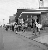
Birmingham Civil Rights Marchers on El Camino Real, May 13, 1963 - Negative
Birmingham Civil Rights Marchers on El Camino Real, May 13, 1963. Black and white negative of Civil Rights marchers along El Camino Real in San Mateo, California. About two dozen people walk past the Peninsula Savings and Loan Association building carrying signs protesting civil rights offenses in Birmingham, Alabama. The signs read: "THIS IS / JUST / THE BEGINNING"; "BIRMINGHAM / POLICE / TERROR / MUST GO!"; "STOP / KKK / SIEGE OF ...
Record Type: Photo
-
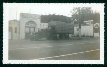
California Floral Co., Redwood City, Photograph, 1940 - Print, Photographic
California Floral Co., Redwood City, Photograph, 1940. This is a black and white photograph of a delivery truck with three workers posed standing on the truck. The truck is stacked high with large flower boxes ready to go to the airport and is parked in front of the long white California Floral Co. building at El Camino Real and 5th Avenue in Redwood City. Alfred Decia is standing on the far right.
Record Type: Photo
-
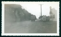
California Floral Co., Redwood City, Photograph, 1940 - Print, Photographic
California Floral Co., Redwood City, Photograph, 1940. This is a black and white photograph with ruffled edges of a delivery truck driving down El Camino Real on the way to the airport. The truck is facing away from the camera, and the road is on the left side of the photograph. The truck is stacked high with large flower boxes. Lining the left side of the road is a row of trees. On the right side of the road are telephone poles and a neon s...
Record Type: Photo
-
California Floral Co., Redwood City, Photograph, c. 1935-1945 - Print, Photographic
California Floral Co., Redwood City, Photograph, c. 1935-1945. This is a black and white photograph taken across the street from the front of the California Floral Co. building at El Camino Real and 5th Avenue in Redwood City. The building is a long white building. There are six cars parked in front of the building. There are three people in front of the building, one is standing and the other two are leaning or sitting on one of the cars nea...
Record Type: Photo
-
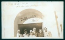
California Floral Co., Redwood City, Photograph, c. 1935-1945 - Print, Photographic
California Floral Co., Redwood City, Photograph, c. 1935-1945. This is a faded black and white photograph. It shows six people posing in front of the doors of the California Floral Co. building at El Camino Real and 5th Avenue in Redwood City. Above themsign reads, "Wholesale Shipper" and "California's Best". There are three men and three women. Alfred and Virginia Decia are on the far right and the other four individuals are visitors from t...
Record Type: Photo
-
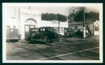
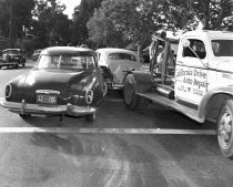
Car Crash on El Camino Real in Burlingame, May 1949 - Negative
Car Crash on El Camino Real in Burlingame, May 1949. Black and white negative shows a California Drive Auto Repair tow truck clearing a car crash on El Camino Real in Burlingame, California. The image shows a dark colored car at left that has crashed its right front bumper into the left rear end of a light colored car visible at center. The car on the left is a Studebaker with a New Mexico license plate and the car at center is a sedan, possibly ...
Record Type: Photo
-
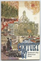
Century 67, Redwood City Historical Trail - Pamphlet
"Century 67, Redwood City Historical Trail," 1967. Pamphlet produced by the Redwood City Centennial Committee that provides information on historical sites and figures of Redwood City. Illustrated.
Record Type: Archive
-
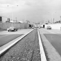
El Camino Real Underpass Near Hillsdale Shopping Center, 1965 - Negative
El Camino Real Underpass Near Hillsdale Shopping Center, 1965. Black and white negative shows the newly constructed underpass at Hillsdale Shopping Center in San Mateo, California. The image appears to be taken from a median strip on El Camino Real. The gravel median runs down the center of the image with two lanes on either side. Several cars drive in each direction. Hillsdale Boulevard is visible in the background, passing over El Camino Real o...
Record Type: Photo
-
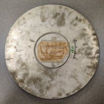
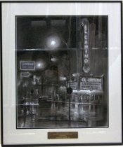
El Camino Theatre by Earl Chamberlin, 1986 - Drawing
1984 El Camino Theatre by Earl Chamberlain. Black and white pastel drawing on paper mounted under glass beneath a white mat with a black inner border inside a black colored aluminum metal frame. There is an engraved brass plaque affixed to glass over bottom center of white mat that reads, "FRED GELLERT FOUNDATION / COLLECTION OF SAN MATEO COUNTY SCENES / EARL CHAMBERLAIN / EL CAMINO THEATRE / PRESENTED BY ART-RISE 1986." Image depicts ...
Record Type: Object
-
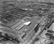
Hillsdale Shopping Center, 1958 - Negative
Hillsdale Shopping Center, 1958. Black and white negative shows an aerial view over Hillsdale Shopping Center looking northwest. Hillsdale Boulevard and El Camino Real are seen in the foreground, with El Camino Real visible on the right side of the shopping center. Macy's appears at center, and Sears Roebuck & Company can be seen at bottom center on the southeast side of Hillsdale Boulevard. In the top left corner is the baseball diamond at Beres...
Record Type: Photo
-
IV-SM-105-A,SM,B; San Mateo-Hayward Bridge to Jct. Rte. 55 (Ralston Ave.) - Document File
IV-SM-105-A,SM,B; San Mateo-Hayward Bridge to Jct. Rte. 55 (Ralston Ave.), 1959-1962. Right of way acquisition documents for parcels of land in San Mateo County. This file concerns two parcels needed for the 19th Avenue and El Camino Real interchange in San Mateo.
Record Type: Archive
-
IV-SM-105-A, SM, B - San Mateo-Hayward Bridge to Jct. Rte. 55 (Ralston Ave.) (Rte. 105-Mi. 1.4 B to Rte. 55-Mi. 2.1B) - Document File
IV-SM-105-A, SM, B - San Mateo-Hayward Bridge to Jct. Rte. 55 (Ralston Ave.) (Rte. 105-Mi. 1.4 B to Rte. 55-Mi. 2.1B), 1957-1958. Right of way acquisition documents for parcels of land in San Mateo County. This file concerns five properties needed for the construction of an interchange at 19th Avenue and El Camino Real in San Mateo.
Record Type: Archive

-
IV-SM-105-SM; San Mateo-Hayward Bridge to Jct. Rte. 55 (Ralston Avenue). - Document File
IV-SM-105-SM; San Mateo-Hayward Bridge to Jct. Rte. 55 (Ralston Avenue), 1957-1962. Right of way acquisition documents for parcels of land in San Mateo County. This file concerns two parcels needed to widen El Camino Real at 19th Avenue in San Mateo.
Record Type: Archive

-
IV-SM-2-Mlbr; El Camino Real - Santa Clara Co. Line to San Francisco Co. Line (Mi. 0.0 MLP to Mi. 1.6 DlC) - Document File
IV-SM-2-Mlbr; El Camino Real - Santa Clara Co. Line to San Francisco Co. Line (Mi. 0.0 MLP to Mi. 1.6 DlC), 1959. Right of way acquisition documents for parcels of land in San Mateo County. This file covers two parcels needed for widening El Camino Real in Millbrae.
Record Type: Archive
