Search Term Record
Metadata
Name |
Dumbarton Bridge |
Number of Archive records |
5 |
Number of Object records |
0 |
Number of Photo records |
2 |
Number of Library records |
1 |
Related Records
-
04-SM-Ala-84-26.7/30.1 - Route 101 in Menlo Park to Route 17 in Fremont (Dumbarton Bridge approaches) - Document File
04-SM-Ala-84-26.7/30.1 - Route 101 in Menlo Park to Route 17 in Fremont (Dumbarton Bridge approaches), 1981. Right of way acquisition documents for parcels of land in San Mateo County. This file focuses on four parcels required for widening Willow Road through east Menlo Park and East Palo Alto.
Record Type: Archive

-
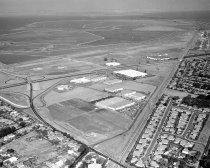
Aerial View of Bohannon Office Park-Menlo Park Business Park - Negative
Aerial View of Bohannon Office Park-Menlo Park Business Park, 1960. Black and white negative shows an aerial view of the Bohannon Office Park-Menlo Park Business Park, looking southeast. There are several large buildings in the office park next to the Bayshore Freeway (Highway 101). The Southern Pacific Railway runs diagonally on right of the image. At the bottom of the photograph is Marsh Road leading to the Dumbarton Bridge.
Record Type: Photo
-
IV-SM-107-B; 59-15-SMA-1 - Grade Toll Plaza (Dumbarton Bridge) - Document File
IV-SM-107-B; 59-15-SMA-1 - Grade Toll Plaza (Dumbarton Bridge), 1959-1961. Right of way acquisition documents for parcels of land in San Mateo County. This file shows planning for the construction of a new Toll Plaza at the west end of the Dumbarton Bridge. The "General Information" section includes a history of the property beginning in 1905, when it was owned by the Spring Valley Water Company.
Record Type: Archive

-
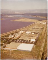
Untitled [Aerial Photograph over Raychem Headquarters] - Photograph, Color
Untitled [Aerial Photograph over Raychem Headquarters], c. late 1960s-1970s. Color photograph shows an aerial view over Raychem Headquarters in Menlo Park, California. A cluster of rectangular buildings appears in the lower half of the image between the Bayfront Expressway at left and train tracks on the right. The photograph is taken looking east with the Dumbarton Bridge in the background.
Record Type: Photo