Search Term Record
Metadata
Name |
Coyote Point |
Number of Archive records |
4 |
Number of Object records |
4 |
Number of Photo records |
84 |
Number of Library records |
2 |
Related Records
-
Aerial, Beginning Development of Brewer Island into Foster City, 1961 - Negative
Black and white negative shows an aerial view looking west of the Brewer Island development into Foster City. Bay Meadows Racetrack is visible at center left, and Coyote Point appears at upper right in the image. The cities of San Mateo, Hillsborough, Burlingame, and Millbrae appear in the distance across the upper portion of the image.
Record Type: Photo
-
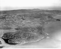
Aerial of Belmont and Brewer Island (Foster City) Looking Northwest, 1961 - Negative
Black and white negative shows an aerial view from Belmont looking northwest over Brewer Island as it is being developed into Foster City. Bayshore Freeway (US 101) runs vertically left of center up from the bottom of the image. Coyote Point appears left of center approximately two-thirds up the image. Steinberger Slough appears in the lower right corner.
Record Type: Photo
-
Aerial of Belmont Hills Looking East - Negative
Black and white negative shows an aerial of Belmont Hills looking east. South San Mateo and Belmont cities appear at center. Brewer Island is visible in the upper portion of the image at center. San Francisco Bay and the East Bay Hills are visible in the background. Mt. Diablo appears at upper right and Coyote Point is visible at upper left.
Record Type: Photo
-
Aerial of Coyote Point and Old Shoreview Looking Southwest - Negative
Aerial of Coyote Point and Old Shoreview Looking Southwest, 1962. Black and white negative shows an aerial view of Coyote Point in San Mateo, California. The photograph was taken looking southwest toward the Shoreview neighborhood with the campus of the College of San Mateo visible at Coyote Point in the foreground at bottom center. The Poplar Creek Golf Course appears behind the campus. The Bayshore Freeway (US 101) runs from upper right in the...
Record Type: Photo
-
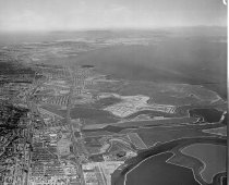
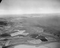
Aerial of Redwood Shores and Brewer Island Looking Northwest, 1961 - Negative
Black and white negative shows an aerial view of undeveloped Redwood Shores and Brewer Island (Foster City) looking northwest. Steinberger Slough appears in the foreground running left to right across the lower portion of the image. Belmont Channel appears nearby with the diamond-shaped Redwood Shores Lagoon visible at lower left. Brewer Island appears at center.
Record Type: Photo
-
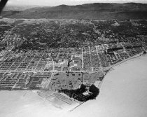
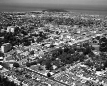
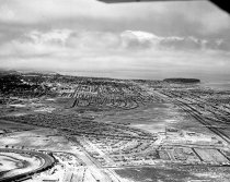
Aerial of San Mateo, 1962 - Negative
Aerial of San Mateo, 1962. Black and white aerial view shows the city of San Mateo looking northwest. San Mateo Village is visible in the foreground of the image at right. El Camino Real runs vertically up through the center of the image. Bay Meadows racetrack appears just below center. Coyote Point appears above center in the distance.
Record Type: Photo
-
Aerial of San Mateo Hills and City of San Mateo Looking North - Negative
Black and white negative shows an aerial of the San Mateo hills before the College of San Mateo was built, looking north towards downtown San Mateo. The Peninsula Golf and Country Club golf course is visible at center right. Coyote Point appears at upper right with the San Francisco Bay in the distance.
Record Type: Photo
-
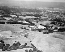
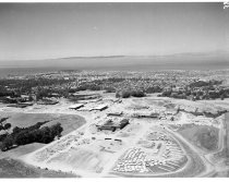
Aerial of the College of San Mateo under Construction, 1962 - Negative
Aerial of the College of San Mateo under Construction, 1962. Black and white negative shows an aerial view looking north of the College of San Mateo. Buildings that are partially constructed appear at center in the landscape. The Tobin Clark mansion and estate is visible at center left, and Coyote Point is visible at top left. The East Bay Hills extend across the top of the image in the distance. Part of a series. See also 2015.001.03932 series.
Record Type: Photo
-
Aerial View of Coyote Point with College of San Mateo Campus, 1962 - Negative
Aerial View of Coyote Point with College of San Mateo Campus, 1962. Black and white negative shows an aerial view of Coyote Point looking south toward the Shoreview neighborhood in San Mateo, California. The College of San Mateo appears surrounded by trees at Coyote Point below center in the image with the Poplar Creek Golf Course just behind it. The Coyote Point Marina and Yacht Harbor appear to the left of the campus. The Bayshore Freeway (High...
Record Type: Photo
-
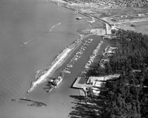
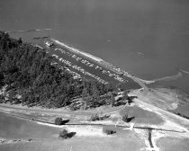
Aerial View of Coyote Point Yacht Club, 1957 - Negative
Aerial View of Coyote Point Yacht Club, 1957. Black and white aerial negative of Coyote Point Yacht Club. There are two rows of yachts anchored in the harbor. At the entrance of the harbor is a dredging barge and beyond that is a sunken boat. A PG&E power station is in the right background near the Old Shoreview neighborhood and the city of San Mateo is in the upper background. Part of a series of 6.
Record Type: Photo
-
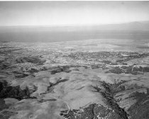
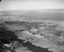
Aerial View of Crystal Springs Reservoir in San Mateo, 1961 - Negative
Aerial View of Crystal Springs Reservoir in San Mateo, 1961. Black and white negative shows an aerial view of Crystal Springs Reservoir in San Mateo. San Mateo-Half Moon Bay Road (Highway 92) crosses the reservoir. Skyline Boulevard (Highway 35) runs along right side of reservoir. Coyote Point is visible in the upper right center of the photograph, and San Francisco Bay and the East Bay are beyond that.
Record Type: Photo
-
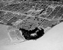
Aerial View of Downtown San Mateo, 1957 - Negative
Aerial View of Downtown San Mateo, 1957. Black and white negative of downtown San Mateo looking north from Maple Street (bottom of photograph) and Mission (far right) to Coyote Point. The San Francisco Bay is on the horizon. The Benjamin Franklin Hotel is visible in the center of the photograph on Fourth Avenue. Part of a series of 12.
Record Type: Photo
-
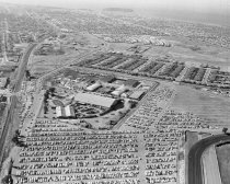
Aerial View of San Mateo County Fairgrounds and Bay Meadows Race Track, 1960 - Negative
Aerial View of San Mateo County Fairgrounds and Bay Meadows Race Track, 1960. Black and white negative showing an aerial view of the San Mateo County Fairgrounds and Bay Meadows race track looking north. A corner of the Bay Meadows race track is seen in the lower right. At the center of the image is a large parking lot full of cars. Coyote Point and the San Francisco Bay are visible in the background near the top of the photograph. Part of a seri...
Record Type: Photo
-
Aerial View of San Mateo Yacht Club Looking Southwest to Northeast, 1957 - Negative
Aerial View of San Mateo Yacht Club Looking Southwest to Northeast, 1957. Black and white aerial negative of the San Mateo Yacht Club looking southwest to northeast with the San Mateo Golf Course in the foreground. Two rows of roughly 100 boats are anchored in the Yacht Club harbor. The boats range from small dinghies to motorboats to sloops. The start of the stand of trees on Coyote Point is visible to the left center of the image. Part of a se...
Record Type: Photo
-
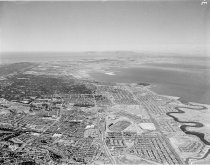
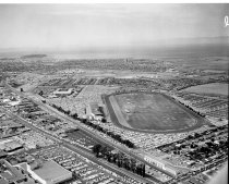
Aerial View of the City of San Mateo, 1961 - Negative
Aerial View of the City of San Mateo, 1961. Black and white negative shows an aerial view of eastern San Mateo, California, looking north. Bay Meadows racetrack can be seen at center. Highway 92 and the 1929 San Mateo-Hayward Drawbridge appear at upper right in the photograph. Hillsdale Shopping Center is in the lower left of the image. In the upper left corner of the image is Coyote Point.
Record Type: Photo
-
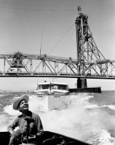
Boating on San Francisco Bay South of Coyote Point, 1959 - Negative
Boating on San Francisco Bay South of Coyote Point, 1959. Black and white negative shows motor boats on the San Francisco Bay, south of Coyote Point. The photograph was taken from a motor boat, with a woman and a small dog just visible in frame at lower left in the back of the boat. A second boat, visible at center, moves toward the camera with water splashing on either side. The 1929 San Mateo-Hayward Drawbridge appears in the background spannin...
Record Type: Photo
-
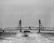
Boating on San Francisco Bay South of Coyote Point Looking Southeast, 1959 - Negative
Boating on San Francisco Bay South of Coyote Point Looking Southeast, 1959. Black and white negative shows motor boats on the San Francisco Bay, south of Coyote Point. One boat appears in the foreground just below center moving toward the camera with water splashing on either side. Several other boats appear in the distance at left. The 1929 San Mateo-Hayward Drawbridge appears behind the boats, spanning the image at center.
Record Type: Photo
-
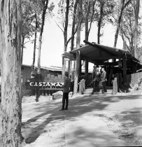
Castaway Restaurant, Coyote Point, San Mateo, July 16, 1965 - Negative
Castaway Restaurant, Coyote Point, San Mateo, July 16, 1965. Black and white negative of Castaway Restaurant at Coyote Point, San Mateo, for Flying Tiger Lines promotion. Part of a series. Description provided by the photographer, Norton Pearl, with assistance from project organizer Cynthia Schreurs.
Record Type: Photo
-
City of San Mateo East of El Camino Real Looking North, August 5, 1956 - Negative
City of San Mateo East of El Camino Real Looking North, August 5, 1956. Black and white negative shows an aerial view of the San Mateo, California, from east of El Camino Real looking north. Bay Meadows Racetrack can be seen in the lower left corner, and the Fiesta Garden development can also be seen just above the racetrack. There is development of an overpass as 19th Avenue expands to Bayshore Freeway. Coyote Point can be seen in the top right...
Record Type: Photo
-
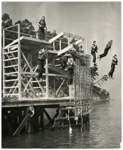
Combat Training Platform, U.S. Merchant Marine Basic School - Print, Photographic
Combat Training Platform, U.S. Merchant Marine Basic School, 1942. Black and white photograph shows cadets from the U.S. Merchant Marine Basic School jumping into the Bay from a wooden platform set on a pier at Coyote Point. Seven men wearing lifejackets appear in the image with five caught mid-jump. A rope net hangs vertically on the right side of the structure. The shoreline of Coyote Point appears in the background.
Record Type: Photo
-
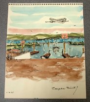
Coyote Point - Painting
Unframed watercolor painting entitled "Coyote Point" by James W. Crawford (American, 1920-2005). Watercolor on paper. January 1, 1975. 10 x 8 inches. Image depicts three docks with a white boat tethered to two of them. Docks are labeled with orange "3" signs. The San Francisco Bay and the East Bay hills can be seen in the background. A plane flies overhead in the top right corner.
Record Type: Object
-
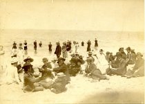
Coyote Point Beachgoers, San Mateo, c. 1887-1888 - Print, Photographic
People at Coyote Point Beach in San Mateo, c. 1887-1888. A group of about 45 men, women, and children on the beach. None are identified.
Record Type: Photo
-
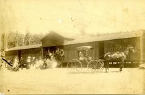
Coyote Point Boathouse, San Mateo, c. 1887-1888 - Print, Photographic
Boathouse at Coyote Point in San Mateo, c. 1887-1888. A horse-drawn carriage with two people in it is in the foreground, and a large group is on the left and in the boathouse. A man with a drum, and apparently wearing a band uniform, is in a group standing in the center opening of the boathouse.
Record Type: Photo
-
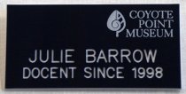
Coyote Point Docent Badge, c. 1999-2016. - Badge, Identification
Coyote Point Docent Badge, c. 1999-2016. Navy blue plastic name tag for Julie Barrow from the Coyote Point Museum. The museum's name and logo of a leaf with a spiral in its center are printed in pale blue at the top right corner. Julie's full name and "DOCENT SINCE 1998" is engraved in larger white text across the bottom. On the back of the name tag, at the top, is a silver metal latching pin closure and a white sticker for "RECOGNITION EXPRESS" ...
Record Type: Object
-
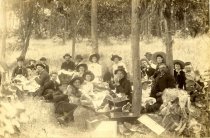
Coyote Point Picnic, San Mateo, c. 1887-1888 - Print, Photographic
Picnic at Coyote Point in San Mateo, c. 1887-1888. A group of 22 people is posing with picnic baskets in a grove of trees.
Record Type: Photo