Search Term Record
Metadata
Name |
Brewer Island |
Number of Archive records |
1 |
Number of Object records |
0 |
Number of Photo records |
19 |
Number of Library records |
3 |
Related Records
-
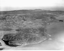
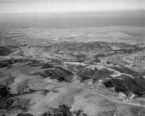
Aerial, Beginning Development of Brewer Island into Foster City, 1961 - Negative
Black and white negative shows an aerial view looking west of the Brewer Island development into Foster City. Bay Meadows Racetrack is visible at center left, and Coyote Point appears at upper right in the image. The cities of San Mateo, Hillsborough, Burlingame, and Millbrae appear in the distance across the upper portion of the image.
Record Type: Photo
-
Aerial of Belmont and Brewer Island (Foster City) Looking Northwest, 1961 - Negative
Black and white negative shows an aerial view from Belmont looking northwest over Brewer Island as it is being developed into Foster City. Bayshore Freeway (US 101) runs vertically left of center up from the bottom of the image. Coyote Point appears left of center approximately two-thirds up the image. Steinberger Slough appears in the lower right corner.
Record Type: Photo
-
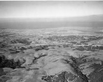
Aerial of Belmont Hills Looking East - Negative
Black and white negative shows an aerial of Belmont Hills looking east. South San Mateo and Belmont cities appear at center. Brewer Island is visible in the upper portion of the image at center. San Francisco Bay and the East Bay Hills are visible in the background. Mt. Diablo appears at upper right and Coyote Point is visible at upper left.
Record Type: Photo
-
Aerial of Belmont Hills Looking Northeast, 1960 - Negative
Aerial of Belmont Hills Looking Northeast, 1960. Black and white negative shows an aerial view of Belmont Hills looking northeast. Farms and country roads (prior to construction of Interstate 280) are visible along the bottom of the image. Carlmont High School appears at center right. Brewer Island (pre development into Foster City) is visible at center in the upper portion of the image with the 1929 San Mateo-Hayward Drawbridge at upper right.
Record Type: Photo
-
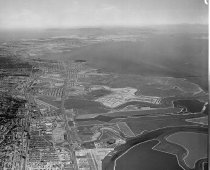
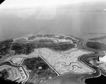
Aerial of Brewer Island (Foster City), 1962 - Negative
Black and white negative shows an aerial view looking south of Brewer Island under development to become Foster City. Brewer Island appears at center with undeveloped Redwood Shores, Bair Island, and the Port of Redwood City in the distance above center. The San Carlos Airport is visible at upper right.
Record Type: Photo
-
Aerial of Brewer Island (Foster City), San Mateo, 1962 - Negative
Aerial of Brewer Island (Foster City), San Mateo, 1962. Black and white negative shows an aerial view of Brewer Island (pre development into Foster City) looking northeast. Belmont Slough is visible at right with the Los Prados neighborhood of San Mateo visible at lower left. The 1929 San Mateo-Hayward Drawbridge is visible just above and left of center, spanning the San Francisco Bay. The bridge extends into the distance toward the upper right c...
Record Type: Photo
-
Aerial of Redwood Shores and Brewer Island Looking Northwest, 1961 - Negative
Black and white negative shows an aerial view of undeveloped Redwood Shores and Brewer Island (Foster City) looking northwest. Steinberger Slough appears in the foreground running left to right across the lower portion of the image. Belmont Channel appears nearby with the diamond-shaped Redwood Shores Lagoon visible at lower left. Brewer Island appears at center.
Record Type: Photo
-
Aerial of the College of San Mateo under Construction, 1962 - Negative
Aerial of the College of San Mateo under Construction, 1962. Black and white negative shows an aerial view of the Construction of the College of San Mateo looking northeast. Buildings that are partially constructed appear across center of the image. The city of San Mateo and Brewer Island (Foster City) are visible in the background. Part of a series.
Record Type: Photo
-
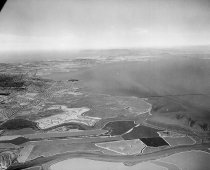
Aerial View of Brewer Island Looking Southwest, April 1962 - Negative
Aerial View of Brewer Island Looking Southwest, April 1962. Black and white negative shows an aerial view of Brewer Island looking southwest before the development of Foster City. The area consists of wetlands and a canal, with a few roads visible. Redwood Shores and Bair Island can be seen in the left of the photograph. In the background is Redwood City. Part of a series of 10.
Record Type: Photo
-
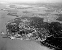
Brewer Island (Foster City) at Onset of Lagoon Construction Development, 1962 - Negative
Black and white negative shows Brewer Island (Foster City) at the onset of lagoon construction development, looking north. Part of a series.
Record Type: Photo
-
Development of Brewer Island into Foster City, 1956-1967 - Negative
Development of Brewer Island into Foster City, 1956-1967. Black and white negative shows an aerial view of Brewer Island and the 1929 San Mateo-Hayward Drawbridge before the development of Foster City. Brewer Island is visible in the foreground along the lower portion of the image, and the drawbridge extends across the image at center. Part of a series. See also series 01771; 02643; 02887; 03037; 03974; 03820; 03078; 04283.
Record Type: Photo
-
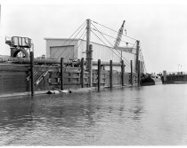
Early Development of Brewer Island into Foster City, c. 1962-1967 - Negative
Early Development of Brewer Island into Foster City, c. 1962-1967. Black and white negative of the filling in and dredging of the canals on Brewer Island during the construction of Foster City. There is a canal to the right of the image, and a pier to the left. There are several cables and posts on the pier as well as a corrugated metal building at the center of the photograph with a large garage door and a crane. There is a large metal canister ...
Record Type: Photo
-
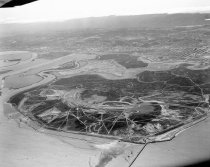
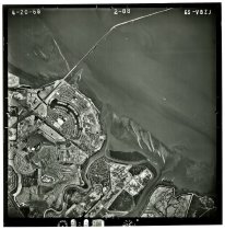
GS-VBZJ 2-88 - Photograph, Black-and-White
GS-VBZJ 2-88, April 20, 1968. Black and white aerial photograph shows an area with parts of Brewer Island (Foster City), Redwood Shores, and the San Mateo-Hayward Bridge. North is oriented to the top of the photograph. Flight by the United States Geological Survey (USGS). An inscription in the right-hand margin indicates the original negative was shot on Kodak Safety film. 9.5" x 9.5" gelatin silver print.
Record Type: Photo
-
Hillsdale Boulevard Bridge to Brewer Island (Foster City), 1962 - Negative
Hillsdale Boulevard Bridge to Brewer Island (Foster City), 1962. Black and white negative shows the Hillsdale Boulevard Bridge looking north toward Brewer Island (Foster City). The photograph was taken from the bank of Seal slough with the bridge visible in the upper portion of the image. Part of a series.
Record Type: Photo
-
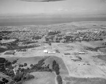
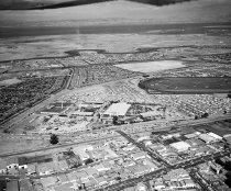
San Mateo County Fairgrounds, August 1962 - Negative
San Mateo County Fairgrounds, August 1962. Black and white negative shows an aerial view of the San Mateo County fairgrounds looking east. Below the fairgrounds, the Souther Pacific Railroad cuts across the image. Brewer Island (future Foster City) is visible in the background towards the San Francisco Bay. A section of the Bay Meadows Racetrack is also visible on the right side of the image Part of a series.
Record Type: Photo
-
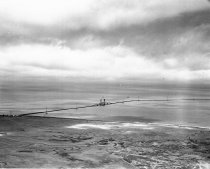
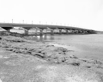
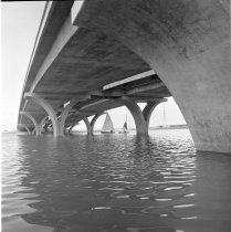
Shell Boulevard Bridge on Brewer Island (Foster City), 1967 - Negative
Shell Boulevard Bridge on Brewer Island (Foster City), 1967. Black and white negative shows the newly constructed Shell Boulevard bridge on Brewer Island (Foster City), California. The image was taken from underneath the bridge and looks out across the water showing the arched bridge support pillars. Two sailboats appear in the background on the other side of the bridge. Brewer Island was incorporated as Foster City in 1971. Part of a Series.
Record Type: Photo
-
The Development of Foster City - Foster, T. Jack, Jr.
The Development of Foster City by T. Jack Foster, Jr.
Record Type: Library
-
The Development of Foster City - Foster, T. Jack, Jr.
The Development of Foster City by T. Jack Foster, Jr.
Record Type: Library