
Search Term Record
Metadata
Name |
Bair Island |
Number of Archive records |
1 |
Number of Object records |
0 |
Number of Photo records |
12 |
Number of Library records |
1 |
Related Records
-
Aerial of Brewer Island (Foster City), 1962 - Negative
Black and white negative shows an aerial view looking south of Brewer Island under development to become Foster City. Brewer Island appears at center with undeveloped Redwood Shores, Bair Island, and the Port of Redwood City in the distance above center. The San Carlos Airport is visible at upper right.
Record Type: Photo
-
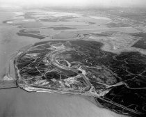
Aerial, Port of Redwood City Looking Due West. - Negative
Black and white negative shows an aerial of the Port of Redwood City looking due west. The Pacific-Portland Cement Company appears at center in the foreground. Redwood City Creek is visible on the right, and Seaport Drive is visible at center. Leslie Salt Plant appears at center, upper right, and salt ponds are visible to the left.
Record Type: Photo
-
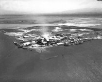
Aerial, Port of Redwood City Looking Southwest - Negative
Black and white negative shows an aerial of the Port of Redwood City looking southwest. The Pacific-Portland Cement Company plant with loading docks appears at center in the image. Directly behind the cement plant are the Bair Island marshlands, the Leslie Salt Company ponds, and the Bayshore Freeway visible near the horizon line.
Record Type: Photo
-
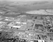
Aerial View of San Carlos Industrial Area, 1967 - Negative
Aerial View of San Carlos Industrial Area, 1967. Black and white negative shows an aerial view of San Carlos industrial area looking northeast. El Camino, the Southern Pacific Railroad, and Old County Road can be seen in the middle of the image and run left to right. Brittan Avenue runs from lower left to the Bayshore Freeway (Highway 101). Bair Island appears at the top of the photograph.
Record Type: Photo
-
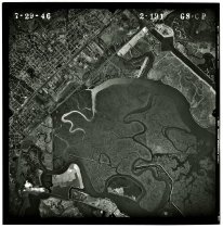
GS-CP 2-191 - Photograph, Black-and-White
GS-CP 2-191, July 29, 1946. Black and white aerial photograph shows Bair Island at lower right and part of San Carlos at upper left. North is oriented to the right side of the photograph. Flight GS-CP by Jack Ammann Photogrammetric Engineers for the United States Geological Survey (USGS). An inscription in the right-hand margin indicates the original negative was shot on Eastman Aerographic Safety film. 9.5" x 9.5" gelatin silver print.
Record Type: Photo
-
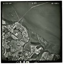
GS-VBZJ 2-88 - Photograph, Black-and-White
GS-VBZJ 2-88, April 20, 1968. Black and white aerial photograph shows an area with parts of Brewer Island (Foster City), Redwood Shores, and the San Mateo-Hayward Bridge. North is oriented to the top of the photograph. Flight by the United States Geological Survey (USGS). An inscription in the right-hand margin indicates the original negative was shot on Kodak Safety film. 9.5" x 9.5" gelatin silver print.
Record Type: Photo
-
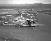
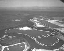
High Altitude Aerial of Leslie Salt Pile and Ponds in Port of Redwood City Looking East. - Negative
Black and white negative shows an aerial of the Leslie Salt Company processing facility and salt evaporation ponds in the Port of Redwood City looking east. The Redwood City Yacht Harbor is visible at center to the right of the salt pile. Redwood Creek appears to the left of the salt pile with Bair Island marshlands in the distance.
Record Type: Photo
-
Untitled [California Audubon Society Bair Island Press Conference] - Photograph, Color
Untitled [California Audubon Society Bair Island Press Conference], January 1997. Two color photographs adhered to a sheet of white paper show a press conference commemorating the Peninsula Open Space Trust’s acquisition of Bair Island in January 1971. A printed inscription at top reads: "Press conference called in January 1997 by California Audubon Society to celebrate the saving of Bair Island in Redwood City from possible development by a Jap...
Record Type: Photo
![Untitled [California Audubon Society Bair Island Press Conference], January](https://s3.amazonaws.com/pastperfectonline/images/museum_136/054/thumbs/2022043001-2.jpg)
-
Untitled [Northwest Port of Redwood City Aerial View] - Photograph, Black-and-White
Untitled [Northwest Port of Redwood City Aerial View], c. 1958-1968. Black and white photograph shows a northwest aerial view of the Port of Redwood City. Bair Island fills the center of the image with the Bayshore Freeway visible along the left and lower left-hand side. Leslie Salt Company facilities and Pete's Harbor appear at bottom center. "Hatfield Aerial Surveys / 274 Leland Avenue / Menlo Park, DA 2-8805" is embossed on the bottom righ...
Record Type: Photo
![Untitled [Northwest Port of Redwood City Aerial View], c. 1958-1968](https://s3.amazonaws.com/pastperfectonline/images/museum_136/054/thumbs/2022035005.jpg)
-
Untitled [Southeast Port of Redwood City Aerial View] - Photograph, Black-and-White
Untitled [Southeast Port of Redwood City Aerial View], January 8, 1957. Black and white photograph mounted to board shows a southeast aerial view of the Port of Redwood City. An adhesive sticker labeled "1957" marks the location of Pete's Harbor above center in the image. Nearby at left are Leslie Salt Company facilities. A section of Bair Island fills the lower half of the image. An inscription on the back notes the date as January 8, 1957.
Record Type: Photo
![Untitled [Southeast Port of Redwood City Aerial View], 1957](https://s3.amazonaws.com/pastperfectonline/images/museum_136/054/thumbs/2022035002.jpg)