Search Term Record
Metadata
Name |
Aerial Views |
Number of Archive records |
4 |
Number of Object records |
2 |
Number of Photo records |
159 |
Number of Library records |
2 |
Related Records
-
Aerial, Beginning Development of Brewer Island into Foster City, 1961 - Negative
Black and white negative shows an aerial view looking west of the Brewer Island development into Foster City. Bay Meadows Racetrack is visible at center left, and Coyote Point appears at upper right in the image. The cities of San Mateo, Hillsborough, Burlingame, and Millbrae appear in the distance across the upper portion of the image.
Record Type: Photo
-
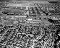
Aerial Looking East of South San Mateo - Negative
Aerial Looking East of South San Mateo, 1958. Black and white negative shows an aerial of South San Mateo looking east. Hillsdale Shopping Center appears in the center of the photograph with West Hillsdale Boulevard running from lower right through center to top center. Bay Meadows racetrack is visible at upper left.
Record Type: Photo
-
Aerial Looking Northwest of Peninsula Hospital, Burlingame After Construction Completed - Negative
Black and white negative shows an aerial looking northwest of the newly constructed Peninsula Hospital in Burlingame. Ray Park subdivision is visible on the left side of the image, and the Burlingame Intermediate School (BIS) is visible in the upper left corner. Trousdale Blvd runs from right center to upper left in the image.
Record Type: Photo
-
Aerial Looking Southeast of Peninsula Hospital, Burlingame under Construction - Negative
Black and white negative shows an aerial looking southeast in Burlingame of the Peninsula Hospital under construction. Trousdale Boulevard runs left to right in the lower part of the image. Ray Park subdivision appears in the center of the photograph above the hospital.
Record Type: Photo

-
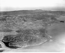
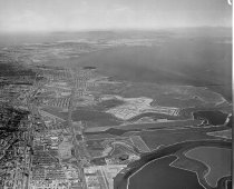
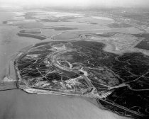
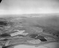
Aerial of Belmont and Brewer Island (Foster City) Looking Northwest, 1961 - Negative
Black and white negative shows an aerial view from Belmont looking northwest over Brewer Island as it is being developed into Foster City. Bayshore Freeway (US 101) runs vertically left of center up from the bottom of the image. Coyote Point appears left of center approximately two-thirds up the image. Steinberger Slough appears in the lower right corner.
Record Type: Photo
-
Aerial of Belmont Hills Looking East - Negative
Black and white negative shows an aerial of Belmont Hills looking east. South San Mateo and Belmont cities appear at center. Brewer Island is visible in the upper portion of the image at center. San Francisco Bay and the East Bay Hills are visible in the background. Mt. Diablo appears at upper right and Coyote Point is visible at upper left.
Record Type: Photo
-
Aerial of Belmont Hills Looking Northeast, 1960 - Negative
Aerial of Belmont Hills Looking Northeast, 1960. Black and white negative shows an aerial view of Belmont Hills looking northeast. Farms and country roads (prior to construction of Interstate 280) are visible along the bottom of the image. Carlmont High School appears at center right. Brewer Island (pre development into Foster City) is visible at center in the upper portion of the image with the 1929 San Mateo-Hayward Drawbridge at upper right.
Record Type: Photo
-
Aerial of Belmont Hills Looking Northwest - Negative
Black and white negative shows an aerial of Belmont Hills looking northwest. Carlmont High School appears at center right. Ralston Avenue is visible running from right to left across the center of the image. The San Mateo Hillsdale area appears behind Ralston Avenue in the upper portion of the image. Bay Meadows Racetrack appears at upper right.
Record Type: Photo
-
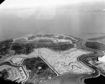
Aerial of Brewer Island (Foster City), 1962 - Negative
Black and white negative shows an aerial view looking south of Brewer Island under development to become Foster City. Brewer Island appears at center with undeveloped Redwood Shores, Bair Island, and the Port of Redwood City in the distance above center. The San Carlos Airport is visible at upper right.
Record Type: Photo
-
Aerial of Brewer Island (Foster City), San Mateo, 1962 - Negative
Aerial of Brewer Island (Foster City), San Mateo, 1962. Black and white negative shows an aerial view of Brewer Island (pre development into Foster City) looking northeast. Belmont Slough is visible at right with the Los Prados neighborhood of San Mateo visible at lower left. The 1929 San Mateo-Hayward Drawbridge is visible just above and left of center, spanning the San Francisco Bay. The bridge extends into the distance toward the upper right c...
Record Type: Photo
-
Aerial of Burlingame Looking South - Negative
Black and white negative shows an aerial of Burlingame looking south with the Peninsula Hospital being constructed in the foreground at bottom center. Trousdale Drive runs in front of and below the hospital. El Camino Real runs to the left of the hospital, and Bayshore Freeway (US 101) runs parallel on the left side of the image.
Record Type: Photo
-
Aerial of Coyote Point and Old Shoreview Looking Southwest - Negative
Aerial of Coyote Point and Old Shoreview Looking Southwest, 1962. Black and white negative shows an aerial view of Coyote Point in San Mateo, California. The photograph was taken looking southwest toward the Shoreview neighborhood with the campus of the College of San Mateo visible at Coyote Point in the foreground at bottom center. The Poplar Creek Golf Course appears behind the campus. The Bayshore Freeway (US 101) runs from upper right in the...
Record Type: Photo
-
Aerial of Downtown San Mateo Looking Southeast - Negative
Black and white negative shows an aerial of downtown San Mateo looking southeast from "the Mounds." Casa Baywood Apartment building appears at center right. South El Camino Real runs from the lower left side of the image through center to the upper right. The Benjamin Franklin Hotel is visible at center left on East 3rd Avenue.
Record Type: Photo
-
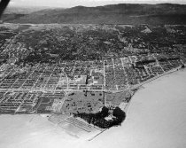
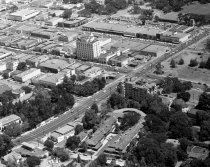
Aerial of Downtown San Mateo Looking Southwest, 1962 - Negative
Black and white negative shows an aerial view of downtown San Mateo looking southwest. The baseball field in Central Park is visible left of center. 5th Avenue runs from lower right up along the right side of the baseball diamond to the upper left corner of the image.
Record Type: Photo
-
Aerial of Downtown San Mateo Looking West, 1962 - Negative
Black and white negative shows an aerial view of downtown San Mateo looking west. Central Park fills the lower left side of the image. The Levy Brothers Department Store is visible at lower right on 4th Avenue. El Camino Real appears at center left and runs above Central Park toward the upper right corner of the image. Benjamin Franklin Hotel is visible right of center on 3rd Avenue.
Record Type: Photo
-
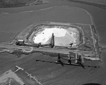
Aerial of Leslie Salt Company in Redwood City, Loading Dock and Operations Facility - Negative
Black and white negative shows an aerial of the Leslie Salt Company loading dock and operations facility in the Port of Redwood City looking southeast. The Redwood City Yacht Harbor is visible in the image at bottom left. The upper portion of the image shows Redwood City Creek behind Leslie Salt Company.
Record Type: Photo
-
Aerial of Redwood Shores and Brewer Island Looking Northwest, 1961 - Negative
Black and white negative shows an aerial view of undeveloped Redwood Shores and Brewer Island (Foster City) looking northwest. Steinberger Slough appears in the foreground running left to right across the lower portion of the image. Belmont Channel appears nearby with the diamond-shaped Redwood Shores Lagoon visible at lower left. Brewer Island appears at center.
Record Type: Photo
-
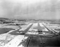
Aerial of San Francisco International Airport Runway Covered with Snow, Looking West, 1962 - Negative
Black and white negative shows an aerial view looking west of a runway covered in snow at the San Francisco International Airport. Sweeney Ridge and San Bruno are visible in the background. Part of a series.
Record Type: Photo
-
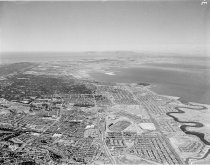
Aerial of San Mateo, 1962 - Negative
Aerial of San Mateo, 1962. Black and white aerial view shows the city of San Mateo looking northwest. San Mateo Village is visible in the foreground of the image at right. El Camino Real runs vertically up through the center of the image. Bay Meadows racetrack appears just below center. Coyote Point appears above center in the distance.
Record Type: Photo
-
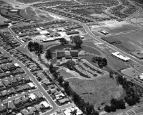
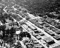
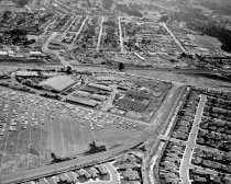
Aerial of San Mateo County Fairgrounds Looking North, 1961 - Negative
Black and white negative shows an aerial view of the San Mateo County Fairgrounds looking north. Southern Pacific train tracks are visible at lower right and run diagonally up to center left in the image. Delaware Street runs right to left in front of the fairgrounds.
Record Type: Photo
-
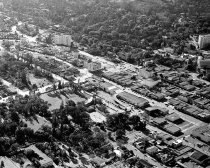
Aerial of San Mateo County Fairgrounds Looking West, 1961 - Negative
Black and white negative shows an aerial view of the San Mateo County Fairgrounds looking west. The Fiesta Gardens neighborhood is visible on the right side of the photo. Saratoga Drive runs from the bottom left corner in a curve up to center right in the image.
Record Type: Photo
-
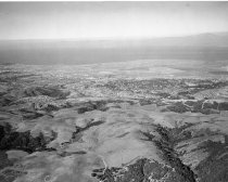
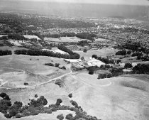
Aerial of San Mateo Hills and City of San Mateo Looking North - Negative
Black and white negative shows an aerial of the San Mateo hills before the College of San Mateo was built, looking north towards downtown San Mateo. The Peninsula Golf and Country Club golf course is visible at center right. Coyote Point appears at upper right with the San Francisco Bay in the distance.
Record Type: Photo
-
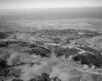
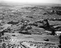
Aerial of San Mateo Hills and City of San Mateo Looking South - Negative
Black and white negative shows an aerial view of San Mateo looking south. The Peninsula Golf and Country Club with its golf course is visible at center. Alameda de las Pulgas runs from center left up through the center of the photo. Serra High School appears at center left. Hillsdale High School appears in the upper portion of the image.
Record Type: Photo
-
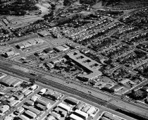
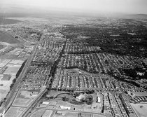
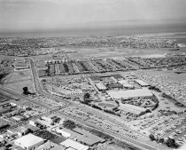
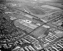
Aerial of South San Mateo Looking North with Hillsdale, Bay Meadows, and San Mateo Fair Grounds - Negative
Aerial of South San Mateo Looking North with Hillsdale, Bay Meadows, and San Mateo Fair Grounds, August 1, 1958. Black and white negative shows an aerial view of South San Mateo looking north. Hillsdale Shopping Center appears at center with El Camino Real running diagonally across the image just behind the shopping center. Bay Meadows racetrack is visible just right of center in the upper portion of the image.
Record Type: Photo
-
Aerial of South San Mateo Villa Hotel and El Camino Real - Negative
Black and white negative shows an aerial of South San Mateo looking southwest from El Camino Real (in foreground). The Villa Motor Hotel, The Lanai, and Villa Chartier restaurant appear in the center of the photo above El Camino Real on the corner of West 39th Avenue.
Record Type: Photo