Person Record
Metadata
Name |
Bromfield, Davenport |
Related Records
-
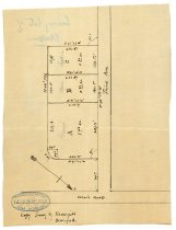
Document File Relating to the Borel Family and Armitage Orphanage. - Document File
Document file relating to the Borel family and Armitage Orphanage. Documents include: 1996.256.001 (A) Hand drawn copy of a survey by Davenport Bromfield, C. E. dated December 19, 1903, showing land division on the Borel estate to Grace, Alice and Sophie. (B) Typewritten document with descriptions of Tract A, B, and C from the office of Davenport Bromfield, C. E. 1996.256.002 - Hand drawn map of building and landscape plans for Armitage ...
Record Type: Archive
-
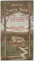
Map of Lomita Park - Pamphlet
Map of Lomita Park, c. 1904. Advertising pamphlet produced by Selby, Rogers & Co. to promote the sale of lots in Lomita Park, "A new suburb of San Francisco outside the fog belt and only forty-five minutes from fifth and Market Streets." Four pages of text note the benefits of the area such as proximity to an electric railway line, availability of utilities, prohibition of the sale of alcohol, and information on terms, taxes, and title. A fold-ou...
Record Type: Archive
-
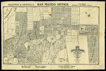
Map of the City of San Mateo Also Showing the Latest Additions and Subdivisions - Map
Map of the City of San Mateo Also Showing the Latest Additions and Subdivisions compiled from Official Maps & Surveys by D. Bromfield, City Engineer, 1907. Bell & Howell real estate map shows a reproduction of Bromfield's 1907 map of San Mateo. The top margin contains an address for Baldwin & Howell's San Mateo Office on 246 B street. The bottom margin has text that reads, "Sole Agents for / San Mateo Park / Hayward Park / Hayward Addition ...
Record Type: Archive
-
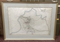
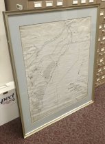
Map Showing the Lands of the Estate of Chas. F. Crocker Dd - Map
Map Showing the Lands of the Estate of Chas. F. Crocker Dd, Davenport Bromfield, c. 1897-1905. Ink map on linen with hand coloring shows buildings, roads, San Mateo Creek, water and sewer lines of the Charles F. Crocker residence in what is now Hillsborough. The grounds are labeled in ink including: Japanese House; Baths; Plunge; Conservatory; Residence; Stables; Izzard's House; Monroe's House; Chicken Yard. Dimensions: 34.25" x 46.25" (framed).
Record Type: Archive
-
Plan of Residence Grounds of Jennie Adeline Crocker - Map
Plan of Residence Grounds of Jennie Adeline Crocker, Davenport Bromfield, April 1926. Ink map on linen with hand coloring shows buildings and roads of the Jennie Adeline Crocker residence. The map references five tracts for a total of 143.62 acres of the residential grounds. Dimensions: 47.5" x 42" (framed).
Record Type: Archive
-
San Mateo County Times Photograph Collection: BRO - BROY (male) - Photograph, Black-and-White
San Mateo County Times photograph collection. This folder contains black and white portrait photographs of men that were used in the daily newspaper known as: the San Mateo County Times; The Times; San Mateo Times and Daily News Leader; Advance Star. The collection is arranged alphabetically by folder. Images are 8" x 10" or smaller. Folder: BRO - BROY (male) Date Range: 1955 - 1991 Individuals: 2017.054.014.1 - Bradafshy, Max 2017.054.014....
Record Type: Photo