
Archive Record
Images
Metadata
Title |
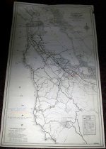
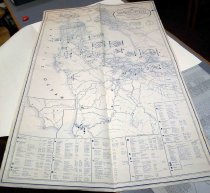
San Mateo County Community Facilities & Defense Data Map and San Mateo County Highway Map, December 1941. |
Object Name |
Map |
Scope & Content |
San Mateo County Community Facilities & Defense Data Map and San Mateo County Highway Map, December 1941. Includes two maps.The first map shows the highways connecting the cities within San Mateo County, with red marks indicating land and bridge routes, blue for water routes, and black for outposts for the US army in World War II. The first map was imprinted by San Mateo County Civilian Defense Council. The second map displays San Mateo County community facilities and defense data important during war efforts. The second map was imprinted by the San Mateo County Planning Commission. Dimensions of Map 1: 61 1/4 x 36.5 Dimensions of Map 2: 30.5 x 18 |
Date |
December 1941 |
Catalog Number |
1969.107 |
Extent of Description |
2-Maps |
Collection |
Archival Collection |
Notes |
"Civil defense, civil defence or civil protection is an effort to protect the citizens of a state (generally non-combatants) from military attacks and natural disasters. It uses the principles of emergency operations: prevention, mitigation, preparation, response, or emergency evacuation and recovery. Programs of this sort were initially discussed at least as early as the 1920s and were implemented in some countries during the 1930s as the threat of war and aerial bombardment grew. It became widespread after the threat of nuclear weapons was realized." [https://en.wikipedia.org/wiki/Civil_defense- 12/27/2016] |
Search Terms |
Civil Defense Civilian Defense Civilian Defense Council San Mateo County San Mateo County Civilian Defense Council San Mateo County Planning Commission War World War II World War Two |
Subjects |
Cities & towns Civil defense Maps War World War II |
Credit line |
SMCHA Collection |