
Archive Record
Images
Metadata
Title |
A Map of Hillsborough Park and Vicinity Showing the Principal Roads and Other Points of Interest in the Year 1930 |
Object Name |
Map |
Scope & Content |
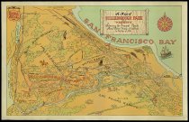
A Map of Hillsborough Park and Vicinity Showing the Principal Roads and Other Points of Interest in the Year 1930. Color pictorial map of Hillsborough Park shows the area of Hillsborough, Burlingame, and San Mateo. The print is an offset lithograph in tones of green, blue, orange, and black. Major roads, Ranchos, and bodies of water are indicated along with small illustrations at points of interest. An inscription at top left reads, "Compiled by David J. Stollery Designed by Herman Struck." Dimensions: 13.5" x 21.25" |
Date |
1930 |
Creator |
Various |
Catalog Number |
1969.091.1-.3 |
Extent of Description |
1 sheet, 13.5" x 21.25" |
Collection |
Archival - Maps |
Search Terms |
Burlingame Hillsborough Rancho Buri Buri Rancho de Las Pulgas Rancho San Mateo San Mateo |
Subjects |
Historic sites Land use Pictorial maps |
People |
Stollery, David J. Struck, Herman |
Credit line |
SMCHA Collection |