Archives
• Search for multiple words by separating them with a single space. Searching for Rocky Pine Ranch will return records that contain Rocky OR Pine OR Ranch or any combination of the three.
• Use an asterisk (*) as a wildcard.
• To search by phrase, wrap your criteria in quotes, e.g. “Rocky Pine Ranch”
• Using AND / OR / NOT connections between words allows you to limit or expand your search criteria.
• You can combine connectors for more specific results by using parenthesis in your search string. As an example, rock OR (pine AND ranch) will return different results than (rock OR pine) AND ranch.
1218 results found sorted by relevance. Records searched: 1218
-
IV-SM-68-SM, C, Bmt, SCar, RdwC, D, MlP - Peninsular Ave. in SM (Mi. 1.91SM) to So. County Boundary (Mi. 0.00D) - Document File
IV-SM-68-SM, C, Bmt, SCar, RdwC, D, MlP - Peninsular Ave. in SM (Mi. 1.91SM) to So. County Boundary (Mi. 0.00D), 1955-1962. Right of way acquisition documents for parcels of land in San Mateo County. This file shows four parcels required for straightening and widening the Bayshore Highway. One parcel contained the Peninsula Celebration Association's Rodeo Grounds.
Record Type: Archive

-
IV-SM-68-SM, C, Bmt, Scar, RdwC, D, MIP - Peninsular Ave. in SM (Mi. 1.91 SM) to So. Co. Boundary (mi. 0.00 D) - Document File
IV-SM-68-SM, C, Bmt, Scar, RdwC, D, MIP - Peninsular Ave. in SM (Mi. 1.91 SM) to So. Co. Boundary (mi. 0.00 D), 1955-1959. Right of way acquisition documents for parcels of land in San Mateo County. This file concerns 15 parcels of land through Belmont, San Carlos, and Redwood City needed for improvement of the Bayshore Freeway.
Record Type: Archive

-
04-SM-186 - 0.2 Mile East of Rte. 280(239) to Rte. 82(2) - Document File
04-SM-186 - 0.2 Mile East of Rte. 280(239) to Rte. 82(2), 1965-1966. Right of way acquisition documents for parcels of land in San Mateo County. This file shows parcels needed for I-380 through San Bruno including a portion of the former Tanforan racetrack. Photographs show undeveloped areas of San Bruno, Daly City, and South San Francisco.
Record Type: Archive

-
04-SM-280-2.4X-22.7X - 0.4 Mi. S. of San Bruno Ave. to 0.2 Mi. S. of Arroyo Drive - Document File
04-SM-280-20.4X-22.7X - 0.4 Mi. S. of San Bruno Ave. to 0.2 Mi. S. of Arroyo Drive, 1966-1968. Right of way acquisition documents for parcels of land in San Mateo County. This file concerns one parcel needed for I-280 through San Bruno, in the area west of Golden Gate National Cemetery and north of Sneath Lane. The property was owned by Cala Foods and included a Littleman Market along with other stores.
Record Type: Archive

-
04-SM-186-6.9-7.6 Route 82 to Route 101 - Document File
04-SM-186-6.9-7.6 Route 82 to Route 101, 1967. Right of way acquisition documents for parcels of land in San Mateo County. This file shows one parcel for the I-380 and Highway 101 interchange in San Bruno on the 900 block of 6th Avenue.
Record Type: Archive

-
04-SM-186-6.9-7.6. Route 82 to Route 101. - Document File
04-SM-186-6.9-7.6. Route 82 to Route 101, 1968-1969. Right of way acquisition documents for parcels of land in San Mateo County. This file contains one parcel on the 900 block of 7th Avenue. The parcel was needed for the I-380 and Highway 101 Interchange in San Bruno.
Record Type: Archive

-
04-SM-186(380) - Mills Avenue to Diamond Street - Document File
04-SM-186(380) - Mills Avenue to Diamond Street, 1969-1970. Right of way acquisition documents for parcels of land in San Mateo County. This file shows property needed for the completion of I-380 through San Bruno. The parcel contains a portion of the former San Francisco Market Street Railway owned by the City and County of San Francisco.
Record Type: Archive

-
04-SM-380 - 1.3 mi. W. of Rte 35 to Rte. 280 in San Bruno - Document File
04-SM-380 - 1.3 mi. W. of Rte 35 to Rte. 280 in San Bruno, 1971-1972. Right of way acquisition documents for parcels of land in San Mateo County. This file shows three service stations needed for I-380 located on San Bruno Avenue near Skyline Boulevard. Interstate 380 went west as far as Interstate 280, and these stations ended up outside the scope of the project.
Record Type: Archive

-
04-SM-28-22.7-25.8; 0.2 Mi. South of Arroyo Dr. to Eastmoor Ave. - Document File
04-SM-28-22.7-25.8; 0.2 Mi. South of Arroyo Dr. to Eastmoor Ave., 1971-1972. Right of way acquisition documents for parcels of land in San Mateo County. This file concerns one parcel needed for a PG&E service line in San Bruno.
Record Type: Archive

-
04-SM-35 - 0.4 Mi. North of Rte. 280 in San Bruno to 0.3 mi. South of Rte. 1 - Document File
04-SM-35 - 0.4 Mi. North of Rte. 280 in San Bruno to 0.3 mi. South of Rte. 1, 1972. Right of way acquisition documents for parcels of land in San Mateo County. This file shows one parcel needed for improvements to Sneath Lane.
Record Type: Archive
-
IV-SM-68-SM-C,Bmt,Scar,RedwC,D,MLP; Peninsular Ave. in SM (Mi. 1.91 SM) to So. County Boundary (Mi. 0.00 D) - Document File
IV-SM-68-SM-C,Bmt,Scar,RedwC,D,MLP; Peninsular Ave. in SM (Mi. 1.91 SM) to So. County Boundary (Mi. 0.00 D), 1953. Right of way acquisition documents for parcels of land in San Mateo County. This file concerns one parcel needed for an interchange with connecting ramps at Holly Street and the Bayshore Highway in San Carlos.
Record Type: Archive

-
IV-SM-68-SM; Peninsular Ave in San Mateo to South County Boundary - Document File
IV-SM-68-SM; Peninsular Ave in San Mateo to South County Boundary, 1951-1952. Right of way acquisition documents for parcels of land in San Mateo County. This file concerns one parcel on 5th Avenue in San Mateo needed for construction of the Bayshore Freeway.
Record Type: Archive

-
IV-SM-2-SM; 3rd Avenue (mi. 3.13) to 25th Ave. (Mi. 1.43) (in City of San Mateo). - Document File
IV-SM-2-SM; 3rd Avenue (mi. 3.13) to 25th Ave. (Mi. 1.43) (in City of San Mateo), 1956-1958. Right of way acquisition documents for parcels of land in San Mateo County. This file covers eight parcels needed to widen El Camino Real between 3rd and 29th Avenue in San Mateo.
Record Type: Archive

-
04-SM-92-R11.6-X12.4 - S of Delaware St in San Mateo to 0.7 Mi E of Norfolk St - Document File
04-SM-92-R11.6-X12.4 - S of Delaware St in San Mateo to 0.7 Mi E of Norfolk St, 1968. Right of way acquisition documents for parcels of land in San Mateo County. This file centers on a parcel located on the northwest side of the 19th Avenue interchange at Bayshore Freeway. The property belonged to Concar Ranch & Enterprises, Inc. owned by Laurence C. Smith. The prominent business in the area was the Unimart Discount Store on an 11-acre site that ...
Record Type: Archive

-
04-SM-92-R11.6-X13.1; S. of Delaware St. in San Mateo to 0.7 Mi. E. of Norfolk St. - Document File
04-SM-92-R11.6-X13.1; S. of Delaware St. in San Mateo to 0.7 Mi. E. of Norfolk St, 1969-1970. Right of way acquisition documents for parcels of land in San Mateo County. This file concerns one parcel needed for the 19th Avenue and Bayshore Interchange project in San Mateo.
Record Type: Archive

-
04-SM-280-5.6-12.6; Raymundo Drive to South End of San Mateo Creek Bridge - Document File
04-SM-280-5.6-12.6; Raymundo Drive to South End of San Mateo Creek Bridge, 1972-1974. Right of way acquisition documents for parcels of land in San Mateo County. This file concerns one parcel needed for fencing and landscaping at the PG&E Jefferson Substation off Canada Road in Woodside.
Record Type: Archive

-
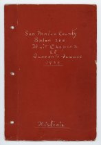
San Mateo County Salon 288 Huit Chapeaux et Quarante Femmes Historie - Scrapbook
San Mateo County Salon 288 Huit Chapeaux et Quarante Femmes Historie, 1939. Scrapbook assembled by Gertrude Lee for Salon 288 of the Huit Chapeax et Quarante Femmes, also known as the Eight and Forty. The Eight and Forty was an honor society for women connected to the American Legion with activities benefitting child welfare. The scrapbook contains: photographs, membership obligations, paper documents and ephemera, newspaper clippings, signatures...
Record Type: Archive
-
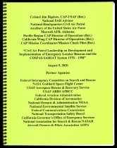
Civil Air Patrol Leadership on Development and Implementation of Emergency Locator Beacons and the COSPAS-SARSAT System 1970-1998 - Report
Civil Air Patrol Leadership on Development and Implementation of Emergency Locator Beacons and the COSPAS-SARSAT System 1970-1998, August 5, 2020. Report by Colonel James D. Bigelow.
Record Type: Archive
-
The History of AutoTrace and the IEEE 200th Milestone Program - Videodisc, Digital
The History of AutoTrace and the IEEE 200th Milestone Program, January 28, 2020. Presentation given by Jim Thompson, Chet Sandberg, Jock Walker, and Wells Whitney at a Raychemer luncheon. The event was held at Michaels at Shorline restaurant on January 28, 2020. Recorded on DVD. Running time 00:43:24.
Record Type: Archive

-
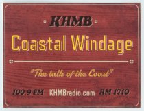
Coastal Windage - Sticker
Coastal Windage Sticker, c. 2020. Two promotional stickers for the radio show "Coastal Windage." The sticker has black, yellow, and gray text printed over a reddish-brown wood background. Text reads, "KMBH / Coastal Windage / 'The talk of the Coast' / 100.9 FM KMBHradio.com AM 1710." A horizontal gray line separates the text at center below "Coastal Windage." Small gray circles with a perpendicular cross created by negative space decorate e...
Record Type: Archive
-
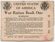
War Ration Books used by the Piccioni Family - Archive
War Ration Books used by the Piccioni Family, c. 1942-1943. Group of War Ration Books used by the Piccioni family during World War II in South San Francisco. 2021.010.001 War Ration Book One, Beppino Joseph Piccioni, No. 327198 4" x 5.25" 2021.010.002 War Ration Book One, Marie Rachelle Piccioni, No.327197 4" x 5.25" 2021.010.003 War Ration Book Four, Beppino Joseph Piccioni, No. 439125 4.25" x 5.75" 2021.010.004 War Ration Bo...
Record Type: Archive
-
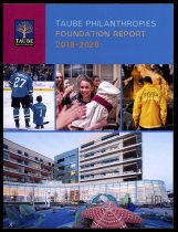
Taube Philanthropies Foundation Report 2018-2020 - Report
Taube Philanthropies Foundation Report 2018-2020. Report on the Taube Philanthropies Foundation, based in Belmont. Softcover report printed in color and illustrated. Sections include: Introduction; Health and Wellness Across the Lifespan; Civic and Cultural Life; Academia and Campus Life; Education: Buildings and Programs; Sports for Youth Programs; Humanitarian Aid and COVID-19 Relief; Jewish Peoplehood; Grants and Leadership 2018-2020. 92 pages
Record Type: Archive
-
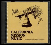
California Mission Music - Disc, Compact
California Mission Music, 1974. Compact Disc contains sacred and secular music presented in concert by The John Biggs Consort in Mission La Purísama Concepcíon, California, September 28 and 29, 1974. The album was released in CD format in 2006 by Consort Press of Ventura, California.
Record Type: Archive
-
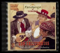
Fandango at Sonoma - Disc, Compact
Fandango at Sonoma, 2009. Compact Disc contains dance music of the late 1800's and early 1900's California performed by The Alta California Orchestra.
Record Type: Archive
-
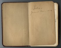
Babies from November 1, 1916 - Archive
Babies from November 1, 1916, November 1, 1916 - September 28, 1935. Handwritten notebook by an unknown author documents births in San Mateo County. Information includes names, number of children, addresses, etc. The notebook has a faux brown leather cover and lined paper in the interior. 134 pages of notes.
Record Type: Archive